Weather Alert in Alaska
Winter Storm Warning issued March 1 at 5:28AM AKST until March 2 at 9:00AM AKST by NWS Juneau AK
AREAS AFFECTED: City of Hyder
DESCRIPTION: ...ANOTHER ROUND OF SNOWFALL EXPECTED SUNDAY FOR CENTRAL PANHANDLE... The active weather pattern continues through Sunday as remnants of yesterday's storm continues to dissipate. Split flow will develop as an incoming front stalls across the central panhandle, with cold strong northerly outflow winds developing across the northern inner channels and warmer southerly winds across the southern panhandle. This sets the stage for portions of the central and southern panhandle to see moderate to heavy snowfall by Sunday afternoon through Sunday evening as another surge of moisture pushes into the area. A transition to a rain snow mix is expected through Monday morning with a transition to rain by Monday afternoon as temperatures increase. Main forecast challenge is potential for temperatures to warm up quicker than expected through Sunday night and into Monday morning with the front moving further north, limiting snowfall accumulations. * WHAT...Heavy snow. Additional snow accumulations of 8 to 12 inches. * WHERE...City of Hyder. * WHEN...Until 9 AM AKST Monday. * IMPACTS...Travel will be very difficult. * ADDITIONAL DETAILS...Prolonged snowfall will continue as another system pushes up from the south through Sunday. A transition to a rain snow mix is expected at times with a transition to predominately rain by Monday afternoon.
INSTRUCTION: If you must travel, keep an extra flashlight, food, and water with you in case of an emergency. People are urged to prepare their property before the onset of winter weather.
Want more detail? Get the Complete 7 Day and Night Detailed Forecast!
Current U.S. National Radar--Current
The Current National Weather Radar is shown below with a UTC Time (subtract 5 hours from UTC to get Eastern Time).

National Weather Forecast--Current
The Current National Weather Forecast and National Weather Map are shown below.

National Weather Forecast for Tomorrow
Tomorrow National Weather Forecast and Tomorrow National Weather Map are show below.

North America Water Vapor (Moisture)
This map shows recent moisture content over North America. Bright and colored areas show high moisture (ie, clouds); brown indicates very little moisture present; black indicates no moisture.

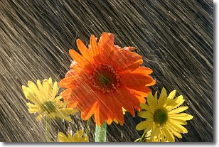
Weather Topic: What is Precipitation?
Home - Education - Precipitation - Precipitation
 Next Topic: Rain
Precipitation can refer to many different forms of water that
may fall from clouds. Precipitation occurs after a cloud has become saturated to
the point where its water particles are more dense than the air below the cloud.
In most cases, precipitation will reach the ground, but it is not uncommon for
precipitation to evaporate before it reaches the earth's surface.
When precipitation evaporates before it contacts the ground it is called Virga.
Graupel, hail, sleet, rain, drizzle, and snow are forms of precipitation, but fog
and mist are not considered precipitation because the water vapor which
constitutes them isn't dense enough to fall to the ground.
Next Topic: Rain
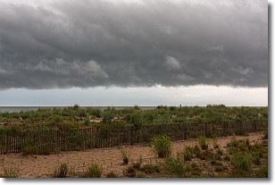
Weather Topic: What are Shelf Clouds?
Home - Education - Cloud Types - Shelf Clouds
 Next Topic: Sleet
A shelf cloud is similar to a wall cloud, but forms at the front
of a storm cloud, instead of at the rear, where wall clouds form.
A shelf cloud is caused by a series of events set into motion by the advancing
storm; first, cool air settles along the ground where precipitation has just fallen.
As the cool air is brought in, the warmer air is displaced, and rises above it,
because it is less dense. When the warmer air reaches the bottom of the storm cloud,
it begins to cool again, and the resulting condensation is a visible shelf cloud.
Next Topic: Sleet
Current conditions powered by WeatherAPI.com


