Weather Alert in Alaska
Winter Weather Advisory issued March 1 at 5:28AM AKST until March 2 at 6:00AM AKST by NWS Juneau AK
AREAS AFFECTED: Prince of Wales Island; City and Borough of Wrangell
DESCRIPTION: ...ANOTHER ROUND OF SNOWFALL EXPECTED SUNDAY FOR CENTRAL PANHANDLE... The active weather pattern continues through Sunday as remnants of yesterday's storm continues to dissipate. Split flow will develop as an incoming front stalls across the central panhandle, with cold strong northerly outflow winds developing across the northern inner channels and warmer southerly winds across the southern panhandle. This sets the stage for portions of the central and southern panhandle to see moderate to heavy snowfall by Sunday afternoon through Sunday evening as another surge of moisture pushes into the area. A transition to a rain snow mix is expected through Monday morning with a transition to rain by Monday afternoon as temperatures increase. Main forecast challenge is potential for temperatures to warm up quicker than expected through Sunday night and into Monday morning with the front moving further north, limiting snowfall accumulations. * WHAT...Snow expected. Total snow accumulations of 5 to 9 inches. * WHERE...Prince of Wales Island and City and Borough of Wrangell. * WHEN...Until 6 AM AKST Monday. * IMPACTS...Travel could be very difficult. The hazardous conditions could impact the morning commute. * ADDITIONAL DETAILS...Highest snowfall totals will remain on the northern side of Prince of Wales Island and upper elevations near Wrangell. Heaviest snowfall rates are expected by Sunday afternoon through Sunday night. Snow ratios will decrease through Sunday night as warm air pushes northward with a transition to a mixed precipitation through late Monday morning.
INSTRUCTION: Slow down and use caution while traveling. People are urged to prepare their property before the onset of winter weather. For the latest road conditions, where available, call 5 1 1 or visit 511.alaska.gov.
Want more detail? Get the Complete 7 Day and Night Detailed Forecast!
Current U.S. National Radar--Current
The Current National Weather Radar is shown below with a UTC Time (subtract 5 hours from UTC to get Eastern Time).

National Weather Forecast--Current
The Current National Weather Forecast and National Weather Map are shown below.

National Weather Forecast for Tomorrow
Tomorrow National Weather Forecast and Tomorrow National Weather Map are show below.

North America Water Vapor (Moisture)
This map shows recent moisture content over North America. Bright and colored areas show high moisture (ie, clouds); brown indicates very little moisture present; black indicates no moisture.

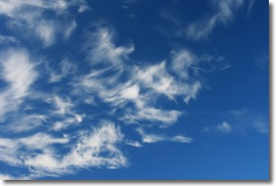
Weather Topic: What are Altostratus Clouds?
Home - Education - Cloud Types - Altostratus Clouds
 Next Topic: Cirrocumulus Clouds
Altostratus clouds form at mid to high-level altitudes
(between 2 and 7 km) and are created by a warm, stable air mass which causes
water vapor
to condense as it rise through the atmosphere. Usually altostratus clouds are
featureless sheets characterized by a uniform color.
In some cases, wind punching through the cloud formation may give it a waved
appearance, called altostratus undulatus. Altostratus clouds
are commonly seen with other cloud formations accompanying them.
Next Topic: Cirrocumulus Clouds
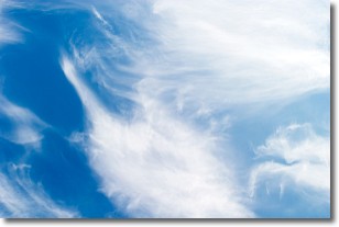
Weather Topic: What are Cirrostratus Clouds?
Home - Education - Cloud Types - Cirrostratus Clouds
 Next Topic: Cirrus Clouds
Cirrostratus clouds are high, thin clouds that form above
20,000 feet and are made mostly of ice crystals. They sometimes look like giant
feathers, horse tails, or curls of hair in the sky.
These clouds are pushed by the jet stream and can move at high speeds reaching
100 mph.
What do they indicate?
They indicate that a precipitation is likely within 24 hours.
Next Topic: Cirrus Clouds
Current conditions powered by WeatherAPI.com


