Weather Alert in Ohio
Flood Warning issued April 1 at 10:04PM EDT until April 4 at 2:00PM EDT by NWS Pittsburgh PA
AREAS AFFECTED: Coshocton, OH
DESCRIPTION: ...The Flood Warning is extended for the following rivers in Ohio... Stillwater Creek At Uhrichsville affecting Tuscarawas County. Muskingum River At Coshocton affecting Coshocton County. * WHAT...Minor flooding is forecast. * WHERE...Muskingum River at Coshocton. * WHEN...From Thursday evening to Saturday afternoon. * IMPACTS...At 13.0 feet, Water reaches low lying areas between Tuscarawas and Walhonding Rivers just upstream of the confluence of the two rivers. At 15.0 feet, Low areas are flooded and water reaches a few homes along Route 16 south of Coshocton and along County Route 1A north of Coshocton. At 16.0 feet, Flood waters begin to affect the Lake Park area along the Walhonding River and begins backwater flooding along Mill Creek north of Lake Park and along Route 83. Flood waters will begin to enter yards in low-lying areas along County Route 1A. * ADDITIONAL DETAILS... - At 9:00 PM EDT Wednesday the stage was 13.0 feet. - Bankfull stage is 13.0 feet. - Forecast...The river is expected to rise above flood stage Thursday evening to a crest of 15.1 feet early Friday morning. It will then fall below flood stage Saturday morning. - Flood stage is 15.0 feet. - Flood History...This crest compares to a previous crest of 15.1 feet on 03/05/1993. - http://www.weather.gov/safety/flood
INSTRUCTION: Motorists should not attempt to drive around barricades or drive cars through flooded areas. Additional information is available at weather.gov/pbz. The next statement will be issued Thursday afternoon at noon EDT.
Want more detail? Get the Complete 7 Day and Night Detailed Forecast!
Current U.S. National Radar--Current
The Current National Weather Radar is shown below with a UTC Time (subtract 5 hours from UTC to get Eastern Time).

National Weather Forecast--Current
The Current National Weather Forecast and National Weather Map are shown below.

National Weather Forecast for Tomorrow
Tomorrow National Weather Forecast and Tomorrow National Weather Map are show below.

North America Water Vapor (Moisture)
This map shows recent moisture content over North America. Bright and colored areas show high moisture (ie, clouds); brown indicates very little moisture present; black indicates no moisture.

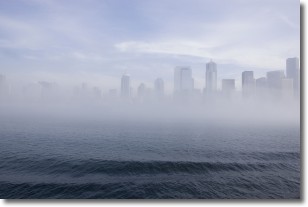
Weather Topic: What is Fog?
Home - Education - Cloud Types - Fog
 Next Topic: Fractus Clouds
Fog is technically a type of stratus cloud, which lies along the
ground and obscures visibility.
It is usually created when humidity in the air condenses into tiny water droplets.
Because of this, some places are more prone to foggy weather, such as regions
close to a body of water.
Fog is similar to mist; both are the appearance of water droplets suspended in
the air, but fog is the term applied to the condition when visibility is less than 1 km.
Next Topic: Fractus Clouds
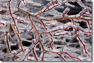
Weather Topic: What is Freezing Rain?
Home - Education - Precipitation - Freezing Rain
 Next Topic: Graupel
Freezing rain is a condition where precipitation which has fallen in the form of
water droplets reaches temperatures which are below freezing and freezes upon
coming into contact
with surface objects. The result of this precipitation is a glaze of ice which
can be damaging to plants and man-made structures. A severe onset of freezing
rain which results in a very thick glaze of ice is known as an ice storm.
Next Topic: Graupel
Current conditions powered by WeatherAPI.com


