Weather Alert in California
Flash Flood Warning issued February 16 at 12:01PM PST until February 16 at 2:00PM PST by NWS Los Angeles/Oxnard CA
AREAS AFFECTED: Los Angeles, CA
DESCRIPTION: FFWLOX The National Weather Service in Los Angeles/Oxnard has issued a * Flash Flood Warning for... Eastern Los Angeles County in southwestern California... * Until 200 PM PST. * At 1201 PM PST, Doppler radar and automated rain gauges indicated thunderstorms producing heavy rain across the warned area. Flash flooding is ongoing or expected to begin shortly. The expected and observed rainfall rate is 0.5 to 0.75 inches in 15 minutes. Flash flooding is already occurring. Rock slides and mud slides are expected. Debris flows on the burn HAZARD...Flash flooding caused by thunderstorms. Significant rock slides and mud slides. Debris flows. SOURCE...Radar and automated gauges. IMPACT...Life threatening flash flooding. Thunderstorms producing flash flooding. Significant rock slides and mud slides. Debris flows. This includes the Bridge Burn Scar. * Some locations that will experience flash flooding include... Long Beach, West Covina, Glendora, San Dimas, Pomona, Whittier, La Verne, Covina, Azusa, Baldwin Park, Diamond Bar, Hacienda Heights, Monrovia, Claremont, Santa Fe Springs, Norwalk, Cerritos, Artesia, Bellflower and Walnut.
INSTRUCTION: Turn around, don't drown when encountering flooded roads. Most flood deaths occur in vehicles. Please report observed flooding to local emergency services or law enforcement and request they pass this information to the National Weather Service when you can do so safely.
Want more detail? Get the Complete 7 Day and Night Detailed Forecast!
Current U.S. National Radar--Current
The Current National Weather Radar is shown below with a UTC Time (subtract 5 hours from UTC to get Eastern Time).

National Weather Forecast--Current
The Current National Weather Forecast and National Weather Map are shown below.

National Weather Forecast for Tomorrow
Tomorrow National Weather Forecast and Tomorrow National Weather Map are show below.

North America Water Vapor (Moisture)
This map shows recent moisture content over North America. Bright and colored areas show high moisture (ie, clouds); brown indicates very little moisture present; black indicates no moisture.

Weather Topic: What are Fractus Clouds?
Home - Education - Cloud Types - Fractus Clouds
 Next Topic: Freezing Rain
A fractus cloud (scud) is a fragmented, tattered cloud which has
likely been sheared off of another cloud. They are accessory clouds, meaning they
develop from parent clouds, and are named in a way which describes the original
cloud which contained them.
Fractus clouds which have originated from cumulus clouds are referred to as
cumulus fractus, while fractus clouds which have originated from stratus clouds
are referred to as stratus fractus. Under certain conditions a fractus cloud might
merge with another cloud, or develop into a cumulus cloud, but usually a
fractus cloud seen by itself will dissipate rapidly.
They are often observed on the leading and trailing edges of storm clouds,
and are a display of wind activity.
Next Topic: Freezing Rain
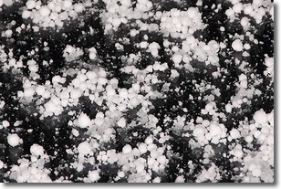
Weather Topic: What is Graupel?
Home - Education - Precipitation - Graupel
 Next Topic: Hail
Graupel is a form of precipitation that is created by atmospheric conditions
which cause supercooled water droplets to contact snow crystals and freeze to
their surface.
Sometimes known as soft hail or snow pellets, graupel is delicate and easily
destroyed by touch. Whereas hail usually falls during severe weather, graupel
doesn't require such conditions to form, and can form in mild precipitation
similar to situations which produce snowfall.
Next Topic: Hail
Current conditions powered by WeatherAPI.com


