Weather Alert in Colorado
Winter Weather Advisory issued February 15 at 11:05PM MST until February 18 at 11:00PM MST by NWS Denver CO
AREAS AFFECTED: South and East Jackson/Larimer/North and Northeast Grand/Northwest Boulder Counties Above 9000 Feet; South and Southeast Grand/West Central and Southwest Boulder/Gilpin/Clear Creek/Summit/North and West Park Counties Above 9000 Feet
DESCRIPTION: * WHAT...Snow expected. Total snow accumulations between 3 and 10 inches, with localized higher amounts up to 12 inches. Winds gusting as high as 70 mph over the mountain passes. * WHERE...Rocky Mountain National Park and the Medicine Bow Range, and The Mountains of Summit County, the Mosquito Range, and the Indian Peaks. * WHEN...From 2 AM Tuesday to 11 PM MST Wednesday. * IMPACTS...Snow and blowing snow will reduce visibility to a quarter mile or less, with potential for sudden snow squalls to bring quick intense bursts of snow and rapidly reduced visibility. Snow and ice covered roads will make travel very difficult at times. The hazardous conditions will impact the Tuesday morning and evening commutes.
INSTRUCTION: Roads will be slick resulting in slow and hazardous travel. Allow extra time to reach your destination. If traveling to the mountains, be prepared for winter driving conditions. Check cotrip.org for road closures and traction laws.
Want more detail? Get the Complete 7 Day and Night Detailed Forecast!
Current U.S. National Radar--Current
The Current National Weather Radar is shown below with a UTC Time (subtract 5 hours from UTC to get Eastern Time).

National Weather Forecast--Current
The Current National Weather Forecast and National Weather Map are shown below.

National Weather Forecast for Tomorrow
Tomorrow National Weather Forecast and Tomorrow National Weather Map are show below.

North America Water Vapor (Moisture)
This map shows recent moisture content over North America. Bright and colored areas show high moisture (ie, clouds); brown indicates very little moisture present; black indicates no moisture.

Weather Topic: What are Contrails?
Home - Education - Cloud Types - Contrails
 Next Topic: Cumulonimbus Clouds
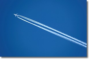
A contrail is an artificial cloud, created by the passing of an
aircraft.
Contrails form because water vapor in the exhaust of aircraft engines is suspended
in the air under certain temperatures and humidity conditions. These contrails
are called exhaust contrails.
Another type of contrail can form due to a temporary reduction in air pressure
moving over the plane's surface, causing condensation.
These are called aerodynamic contrails.
When you can see your breath on a cold day, it is also because of condensation.
The reason contrails last longer than the condensation from your breath is
because the water in contrails freezes into ice particles.
Next Topic: Cumulonimbus Clouds
Weather Topic: What are Cumulus Clouds?
Home - Education - Cloud Types - Cumulus Clouds
 Next Topic: Drizzle
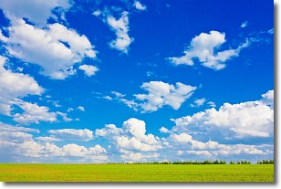
Cumulus clouds are fluffy and textured with rounded tops, and
may have flat bottoms. The border of a cumulus cloud
is clearly defined, and can have the appearance of cotton or cauliflower.
Cumulus clouds form at low altitudes (rarely above 2 km) but can grow very tall,
becoming cumulus congestus and possibly the even taller cumulonimbus clouds.
When cumulus clouds become taller, they have a greater chance of producing precipitation.
Next Topic: Drizzle
Current conditions powered by WeatherAPI.com


