Weather Alert in California
High Wind Warning issued February 16 at 12:33AM PST until February 16 at 6:00PM PST by NWS Los Angeles/Oxnard CA
AREAS AFFECTED: Cuyama Valley; San Luis Obispo County Interior Valleys; San Luis Obispo County Mountains; Santa Barbara County Interior Mountains; Southern Ventura County Mountains; Interstate 5 Corridor; Western San Gabriel Mountains and Highway 14 Corridor; Western Antelope Valley Foothills; Eastern Antelope Valley Foothills
DESCRIPTION: * WHAT...Southwest winds 30 to 55 mph with gusts up to 70 mph possible. Strongest in the mountains. * WHERE...Cuyama Valley, Eastern Antelope Valley Foothills, Interstate 5 Corridor, San Luis Obispo County Interior Valleys, San Luis Obispo County Mountains, Santa Barbara County Interior Mountains, Southern Ventura County Mountains, Western Antelope Valley Foothills, and Western San Gabriel Mountains and Highway 14 Corridor. * WHEN...From 6 AM this morning to 6 PM PST this evening. * IMPACTS...Damaging winds could blow down trees and power lines. Travel could be difficult, especially for high-profile vehicles.
INSTRUCTION: Remain in the lower levels of your home during the windstorm, and stay away from windows. Watch for falling debris and tree limbs. Use caution if you must drive.
Want more detail? Get the Complete 7 Day and Night Detailed Forecast!
Current U.S. National Radar--Current
The Current National Weather Radar is shown below with a UTC Time (subtract 5 hours from UTC to get Eastern Time).

National Weather Forecast--Current
The Current National Weather Forecast and National Weather Map are shown below.

National Weather Forecast for Tomorrow
Tomorrow National Weather Forecast and Tomorrow National Weather Map are show below.

North America Water Vapor (Moisture)
This map shows recent moisture content over North America. Bright and colored areas show high moisture (ie, clouds); brown indicates very little moisture present; black indicates no moisture.

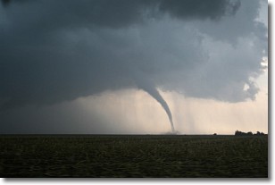
Weather Topic: What are Wall Clouds?
Home - Education - Cloud Types - Wall Clouds
 Next Topic: Altocumulus Clouds
A wall cloud forms underneath the base of a cumulonimbus cloud,
and can be a hotbed for deadly tornadoes.
Wall clouds are formed by air flowing into the cumulonimbus clouds, which can
result in the wall cloud descending from the base of the cumulonimbus cloud, or
rising fractus clouds which join to the base of the storm cloud as the wall cloud
takes shape.
Wall clouds can be very large, and in the Northern Hemisphere they generally
form at the southern edge of cumulonimbus clouds.
Next Topic: Altocumulus Clouds
Weather Topic: What are Altostratus Clouds?
Home - Education - Cloud Types - Altostratus Clouds
 Next Topic: Cirrocumulus Clouds
Altostratus clouds form at mid to high-level altitudes
(between 2 and 7 km) and are created by a warm, stable air mass which causes
water vapor
to condense as it rise through the atmosphere. Usually altostratus clouds are
featureless sheets characterized by a uniform color.
In some cases, wind punching through the cloud formation may give it a waved
appearance, called altostratus undulatus. Altostratus clouds
are commonly seen with other cloud formations accompanying them.
Next Topic: Cirrocumulus Clouds
Current conditions powered by WeatherAPI.com


