Weather Alert in Wisconsin
Special Weather Statement issued April 2 at 8:54PM CDT by NWS Green Bay WI
AREAS AFFECTED: Lincoln; Langlade; Menominee; Northern Oconto County; Marathon; Shawano; Wood; Portage; Waupaca
DESCRIPTION: At 845 PM, an area of rain was lifting northeast across central Wisconsin and the Fox Valley at 45 mph. This rain was moving into an area where temperatures remain 32 to 33 degrees across Marathon and Shawano counties, as well as from Lincoln to northern Oconto counties. As a result, this rain will likely freeze onto elevated surfaces and lead to slippery roads in some areas. If traveling in this area, particularly on HWY 29 and HWY 64, remain alert for changing road conditions and drive with caution.
INSTRUCTION: N/A
Want more detail? Get the Complete 7 Day and Night Detailed Forecast!
Current U.S. National Radar--Current
The Current National Weather Radar is shown below with a UTC Time (subtract 5 hours from UTC to get Eastern Time).

National Weather Forecast--Current
The Current National Weather Forecast and National Weather Map are shown below.

National Weather Forecast for Tomorrow
Tomorrow National Weather Forecast and Tomorrow National Weather Map are show below.

North America Water Vapor (Moisture)
This map shows recent moisture content over North America. Bright and colored areas show high moisture (ie, clouds); brown indicates very little moisture present; black indicates no moisture.

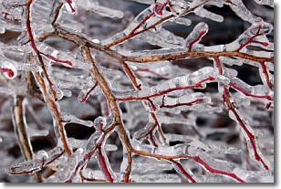
Weather Topic: What is Freezing Rain?
Home - Education - Precipitation - Freezing Rain
 Next Topic: Graupel
Freezing rain is a condition where precipitation which has fallen in the form of
water droplets reaches temperatures which are below freezing and freezes upon
coming into contact
with surface objects. The result of this precipitation is a glaze of ice which
can be damaging to plants and man-made structures. A severe onset of freezing
rain which results in a very thick glaze of ice is known as an ice storm.
Next Topic: Graupel
Weather Topic: What is Hail?
Home - Education - Precipitation - Hail
 Next Topic: Hole Punch Clouds
Hail is a form of precipitation which is recognized by large solid balls or
clumps of ice. Hail is created by thunderstorm clouds with strong updrafts of wind.
As the hailstones remain in the updraft, ice is deposited onto them until their
weight becomes heavy enough for them to fall to the earth's surface.
Hail storms can cause significant damage to crops, aircrafts, and man-made structures,
despite the fact that the duration is usually less than ten minutes.
Next Topic: Hole Punch Clouds
Current conditions powered by WeatherAPI.com


