Weather Alert in Kansas
Red Flag Warning issued February 15 at 9:24PM CST until February 17 at 8:00PM CST by NWS Dodge City KS
AREAS AFFECTED: Trego; Ellis; Scott; Lane; Ness; Rush; Hamilton; Kearny; Finney; Hodgeman; Pawnee; Stafford; Stanton; Grant; Haskell; Gray; Ford; Edwards; Kiowa; Pratt; Morton; Stevens; Seward; Meade; Clark; Comanche; Barber
DESCRIPTION: The National Weather Service in Dodge City has issued a Red Flag Warning for wind and low relative humidity, which is in effect from noon CST /11 AM MST/ to 8 PM CST /7 PM MST/ Tuesday. The Fire Weather Watch is no longer in effect. * AFFECTED AREA...Fire Weather Zone 030 Trego, Fire Weather Zone 031 Ellis, Fire Weather Zone 043 Scott, Fire Weather Zone 044 Lane, Fire Weather Zone 045 Ness, Fire Weather Zone 046 Rush, Fire Weather Zone 061 Hamilton, Fire Weather Zone 062 Kearny, Fire Weather Zone 063 Finney, Fire Weather Zone 064 Hodgeman, Fire Weather Zone 065 Pawnee, Fire Weather Zone 066 Stafford, Fire Weather Zone 074 Stanton, Fire Weather Zone 075 Grant, Fire Weather Zone 076 Haskell, Fire Weather Zone 077 Gray, Fire Weather Zone 078 Ford, Fire Weather Zone 079 Edwards, Fire Weather Zone 080 Kiowa, Fire Weather Zone 081 Pratt, Fire Weather Zone 084 Morton, Fire Weather Zone 085 Stevens, Fire Weather Zone 086 Seward, Fire Weather Zone 087 Meade, Fire Weather Zone 088 Clark, Fire Weather Zone 089 Comanche and Fire Weather Zone 090 Barber. * TIMING...From noon CST /11 AM MST/ to 8 PM CST /7 PM MST/ Tuesday. * WINDS...Southwest 25 to 45 mph with gusts of 50 mph and higher. * RELATIVE HUMIDITY...As low as 10 percent. * IMPACTS...Any fire that develops will catch and spread quickly. Outdoor burning is not recommended.
INSTRUCTION: A Red Flag Warning means that critical fire weather conditions are either occurring now, or will shortly. A combination of strong winds, low relative humidity, and warm temperatures can contribute to extreme fire behavior.
Want more detail? Get the Complete 7 Day and Night Detailed Forecast!
Current U.S. National Radar--Current
The Current National Weather Radar is shown below with a UTC Time (subtract 5 hours from UTC to get Eastern Time).

National Weather Forecast--Current
The Current National Weather Forecast and National Weather Map are shown below.

National Weather Forecast for Tomorrow
Tomorrow National Weather Forecast and Tomorrow National Weather Map are show below.

North America Water Vapor (Moisture)
This map shows recent moisture content over North America. Bright and colored areas show high moisture (ie, clouds); brown indicates very little moisture present; black indicates no moisture.

Weather Topic: What are Contrails?
Home - Education - Cloud Types - Contrails
 Next Topic: Cumulonimbus Clouds
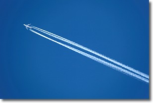
A contrail is an artificial cloud, created by the passing of an
aircraft.
Contrails form because water vapor in the exhaust of aircraft engines is suspended
in the air under certain temperatures and humidity conditions. These contrails
are called exhaust contrails.
Another type of contrail can form due to a temporary reduction in air pressure
moving over the plane's surface, causing condensation.
These are called aerodynamic contrails.
When you can see your breath on a cold day, it is also because of condensation.
The reason contrails last longer than the condensation from your breath is
because the water in contrails freezes into ice particles.
Next Topic: Cumulonimbus Clouds
Weather Topic: What are Cumulus Clouds?
Home - Education - Cloud Types - Cumulus Clouds
 Next Topic: Drizzle
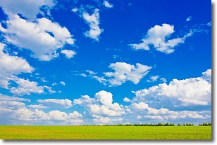
Cumulus clouds are fluffy and textured with rounded tops, and
may have flat bottoms. The border of a cumulus cloud
is clearly defined, and can have the appearance of cotton or cauliflower.
Cumulus clouds form at low altitudes (rarely above 2 km) but can grow very tall,
becoming cumulus congestus and possibly the even taller cumulonimbus clouds.
When cumulus clouds become taller, they have a greater chance of producing precipitation.
Next Topic: Drizzle
Current conditions powered by WeatherAPI.com


