Weather Alert in Idaho
Avalanche Advisory issued February 21 at 5:55AM MST by NWS Pocatello ID
AREAS AFFECTED: Bear River Range
DESCRIPTION: SABPIH The following message is transmitted at the request of the Forest Service Utah Avalanche Center. The Forest Service Utah Avalanche Center has issued a SPECIAL AVALANCHE BULLETIN for the following areas: * WHAT...Dangerous avalanche conditions are possible across the Bear River Range and surrounding mountains across northern Utah this weekend. This week's heavy snowfall and strong winds overloaded preexisting weak layers, creating HIGH avalanche danger. With improving weather moving in for the weekend, avalanche accidents are likely in the backcountry. There have already been two avalanche fatalities this week, as well as several close calls and numerous backcountry avalanches reported. * WHERE...Bear River Range and surrounding mountains across northern Utah. * WHEN...6 AM MST Monday. * IMPACTS...Dangerous avalanche conditions exist in the mountains and will persist through the weekend.
INSTRUCTION: Natural avalanches are possible, and people are likely to trigger avalanches on slopes steeper than 30 degrees. Dangerous and deadly avalanches can be triggered remotely from a distance or from below. People leaving ski area boundaries are entering the backcountry where the same dangerous avalanche conditions exist. Consult www.utahavalanchecenter.org or www.avalanche.org for more detailed information. Similar avalanche danger may exist at locations outside the coverage area of this or any avalanche center.
Want more detail? Get the Complete 7 Day and Night Detailed Forecast!
Current U.S. National Radar--Current
The Current National Weather Radar is shown below with a UTC Time (subtract 5 hours from UTC to get Eastern Time).

National Weather Forecast--Current
The Current National Weather Forecast and National Weather Map are shown below.

National Weather Forecast for Tomorrow
Tomorrow National Weather Forecast and Tomorrow National Weather Map are show below.

North America Water Vapor (Moisture)
This map shows recent moisture content over North America. Bright and colored areas show high moisture (ie, clouds); brown indicates very little moisture present; black indicates no moisture.

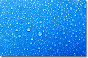
Weather Topic: What is Condensation?
Home - Education - Precipitation - Condensation
 Next Topic: Contrails
Condensation is the process which creates clouds, and therefore
it is a crucial process in the water cycle.
Condensation is the change of matter from a state of gas into a state of liquid,
and it happens because water molecules release heat into the atmosphere and
become organized into a more closely packed structure, what we might see as
water droplets.
Water is always present in the air around us as a vapor, but it's too small for
us to see. When water undergoes the process of condensation it becomes organized
into visible water droplets. You've probably seen condensation happen before on the
surface of a cold drink!
Next Topic: Contrails
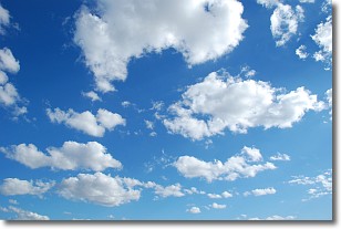
Weather Topic: What are Cumulonimbus Clouds?
Home - Education - Cloud Types - Cumulonimbus Clouds
 Next Topic: Cumulus Clouds
The final form taken by a growing cumulus cloud is the
cumulonimbus cloud, which is very tall and dense.
The tower of a cumulonimbus cloud can soar 23 km into the atmosphere, although
most commonly they stop growing at an altitude of 6 km.
Even small cumulonimbus clouds appear very large in comparison to other cloud types.
They can signal the approach of stormy weather, such as thunderstorms or blizzards.
Next Topic: Cumulus Clouds
Current conditions powered by WeatherAPI.com


