Weather Alert in Minnesota
Winter Storm Watch issued February 15 at 2:32PM CST until February 19 at 12:00PM CST by NWS Duluth MN
AREAS AFFECTED: Koochiching; North St. Louis; Northern Cook/Northern Lake; North Itasca; Central St. Louis; North Cass; South Itasca; Northern Aitkin; Carlton/South St. Louis
DESCRIPTION: * WHAT...Heavy snow, patchy blowing snow, and mixed precipitation possible. There is a 50 to 90 percent chance for total snow accumulations in excess of 6 inches, highest for the higher terrain of the North Shore. There is also a 20 to 70 percent chance for at least a glaze of ice accumulations. Winds could gust as high as 35 mph. * WHERE...Northern Aitkin, Koochiching, North Cass, Itasca, Carlton, St. Louis, and Northern Cook and Lake Counties. This includes the Tribal Lands of the Fond du Lac Band, the Mille Lacs Band, Big Sandy Lake area and the Bois Forte Band, Nett Lake, Deer Creek and, Lake Vermilion areas. Other locations including Voyageurs National Park. The entire Boundary Waters is also included. * WHEN...From Tuesday evening through Thursday morning. * IMPACTS...Travel could be very difficult. The hazardous conditions could impact the Tuesday evening, Wednesday, and Thursday morning commutes. * ADDITIONAL DETAILS...Periods of gusty winds and visibility of less than one quarter mile are possible in the Winter Storm Watch area. The best potential for a wintry mix will be along and south of the Iron Range Tuesday evening into Wednesday morning.
INSTRUCTION: Monitor the latest forecasts for updates on this situation.
Want more detail? Get the Complete 7 Day and Night Detailed Forecast!
Current U.S. National Radar--Current
The Current National Weather Radar is shown below with a UTC Time (subtract 5 hours from UTC to get Eastern Time).

National Weather Forecast--Current
The Current National Weather Forecast and National Weather Map are shown below.

National Weather Forecast for Tomorrow
Tomorrow National Weather Forecast and Tomorrow National Weather Map are show below.

North America Water Vapor (Moisture)
This map shows recent moisture content over North America. Bright and colored areas show high moisture (ie, clouds); brown indicates very little moisture present; black indicates no moisture.

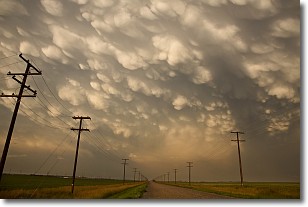
Weather Topic: What are Mammatus Clouds?
Home - Education - Cloud Types - Mammatus Clouds
 Next Topic: Nimbostratus Clouds
A mammatus cloud is a cloud with a unique feature which resembles
a web of pouches hanging along the base of the cloud.
In the United States, mammatus clouds tend to form in the warmer months, commonly
in the Midwest and eastern regions.
While they usually form at the bottom of a cumulonimbis cloud, they can also form
under altostratus, altocumulus, stratocumulus, and cirrus clouds. Mammatus clouds
warn that severe weather is close.
Next Topic: Nimbostratus Clouds
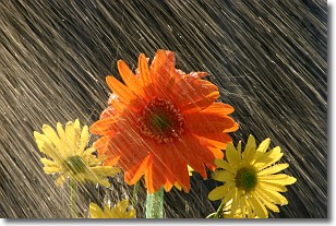
Weather Topic: What is Precipitation?
Home - Education - Precipitation - Precipitation
 Next Topic: Rain
Precipitation can refer to many different forms of water that
may fall from clouds. Precipitation occurs after a cloud has become saturated to
the point where its water particles are more dense than the air below the cloud.
In most cases, precipitation will reach the ground, but it is not uncommon for
precipitation to evaporate before it reaches the earth's surface.
When precipitation evaporates before it contacts the ground it is called Virga.
Graupel, hail, sleet, rain, drizzle, and snow are forms of precipitation, but fog
and mist are not considered precipitation because the water vapor which
constitutes them isn't dense enough to fall to the ground.
Next Topic: Rain
Current conditions powered by WeatherAPI.com


