Weather Alert in Minnesota
Winter Storm Watch issued February 15 at 2:32PM CST until February 19 at 12:00PM CST by NWS Duluth MN
AREAS AFFECTED: Southern Lake/North Shore; Southern Cook/North Shore
DESCRIPTION: * WHAT...Blizzard conditions possible. There is an 80 to 95 percent chance for total snow accumulations in excess of 6 inches and a 50 to 90 percent chance for total snow accumulations in excess of 12 inches. Ice accumulations around a light glaze possible. Winds could gust as high as 50 mph. * WHERE...Southern Cook and Southern Lake Counties. This includes the Tribal Lands of the Grand Portage Reservation. * WHEN...From Tuesday evening through Thursday morning. * IMPACTS...Travel could be very difficult to impossible. Areas of blowing snow could significantly reduce visibility. The hazardous conditions could impact the Tuesday evening, Wednesday, and Thursday morning commutes. * ADDITIONAL DETAILS...Expect terrain and lake enhancement to snowfall totals and snowfall rates. The heaviest snowfall rates will be Tuesday night and Wednesday morning. Winds will be strongest Tuesday evening into Wednesday morning. The best potential for a wintry mix will be along and southwest of Silver Bay Tuesday evening into Wednesday morning.
INSTRUCTION: Prepare for possible blizzard conditions, especially whiteout conditions along Highway 61 on the North Shore. Continue to monitor the latest forecasts for updates on this situation. Persons should consider delaying travel. If travel is absolutely necessary, drive with extreme caution. Consider taking a winter storm kit along with you, including such items as tire chains, booster cables, flashlight, shovel, blankets and extra clothing. Also take water, a first aid kit, and anything else that would help you survive in case you become stranded.
Want more detail? Get the Complete 7 Day and Night Detailed Forecast!
Current U.S. National Radar--Current
The Current National Weather Radar is shown below with a UTC Time (subtract 5 hours from UTC to get Eastern Time).

National Weather Forecast--Current
The Current National Weather Forecast and National Weather Map are shown below.

National Weather Forecast for Tomorrow
Tomorrow National Weather Forecast and Tomorrow National Weather Map are show below.

North America Water Vapor (Moisture)
This map shows recent moisture content over North America. Bright and colored areas show high moisture (ie, clouds); brown indicates very little moisture present; black indicates no moisture.

Weather Topic: What is Condensation?
Home - Education - Precipitation - Condensation
 Next Topic: Contrails
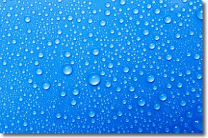
Condensation is the process which creates clouds, and therefore
it is a crucial process in the water cycle.
Condensation is the change of matter from a state of gas into a state of liquid,
and it happens because water molecules release heat into the atmosphere and
become organized into a more closely packed structure, what we might see as
water droplets.
Water is always present in the air around us as a vapor, but it's too small for
us to see. When water undergoes the process of condensation it becomes organized
into visible water droplets. You've probably seen condensation happen before on the
surface of a cold drink!
Next Topic: Contrails
Weather Topic: What are Cumulonimbus Clouds?
Home - Education - Cloud Types - Cumulonimbus Clouds
 Next Topic: Cumulus Clouds
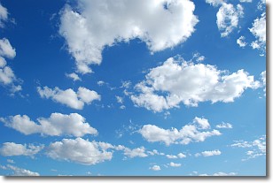
The final form taken by a growing cumulus cloud is the
cumulonimbus cloud, which is very tall and dense.
The tower of a cumulonimbus cloud can soar 23 km into the atmosphere, although
most commonly they stop growing at an altitude of 6 km.
Even small cumulonimbus clouds appear very large in comparison to other cloud types.
They can signal the approach of stormy weather, such as thunderstorms or blizzards.
Next Topic: Cumulus Clouds
Current conditions powered by WeatherAPI.com


