Weather Alert in Minnesota
Winter Storm Watch issued February 16 at 2:05AM CST until February 19 at 12:00PM CST by NWS Duluth MN
AREAS AFFECTED: Southern Lake/North Shore; Southern Cook/North Shore
DESCRIPTION: * WHAT...Blizzard conditions possible. Total snow accumulations between 10 and 15 inches and ice accumulations around one tenth of an inch possible. Winds could gust as high as 50 mph. * WHERE...Southern Cook and Southern Lake Counties. This includes the Tribal Lands of the Grand Portage Reservation. * WHEN...From Tuesday evening through Thursday morning. * IMPACTS...Visibilities may drop below 1/4 mile due to falling and blowing snow. Travel could be very difficult to impossible. Areas of blowing snow could significantly reduce visibility. The hazardous conditions could impact the Wednesday morning and evening commutes. Strong winds could cause tree damage. * ADDITIONAL DETAILS...Expect terrain and lake enhancement to snowfall totals and snowfall rates. The heaviest snowfall rates will be Tuesday night and Wednesday morning. Winds will be strongest Tuesday evening into Wednesday morning. The best potential for a wintry mix will be along and southwest of Silver Bay Tuesday evening into Wednesday morning.
INSTRUCTION: Prepare for possible blizzard conditions. Continue to monitor the latest forecasts for updates on this situation. Prepare for possible blizzard conditions, especially whiteout conditions along Highway 61 on the North Shore. Continue to monitor the latest forecasts for updates on this situation.
Want more detail? Get the Complete 7 Day and Night Detailed Forecast!
Current U.S. National Radar--Current
The Current National Weather Radar is shown below with a UTC Time (subtract 5 hours from UTC to get Eastern Time).

National Weather Forecast--Current
The Current National Weather Forecast and National Weather Map are shown below.

National Weather Forecast for Tomorrow
Tomorrow National Weather Forecast and Tomorrow National Weather Map are show below.

North America Water Vapor (Moisture)
This map shows recent moisture content over North America. Bright and colored areas show high moisture (ie, clouds); brown indicates very little moisture present; black indicates no moisture.

Weather Topic: What is Drizzle?
Home - Education - Precipitation - Drizzle
 Next Topic: Evaporation
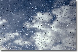
Drizzle is precipitation in the form of water droplets which are
smaller than raindrops.
Drizzle is characterized by fine, gently falling droplets and typically does not
impact human habitation in a negative way. The exception to this is freezing drizzle,
a condition where drizzle freezes immediately upon reaching earth's surface.
Freezing drizzle is still less dangerous than freezing rain, but can
potentially result in hazardous road conditions.
Next Topic: Evaporation
Weather Topic: What is Fog?
Home - Education - Cloud Types - Fog
 Next Topic: Fractus Clouds
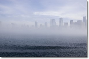
Fog is technically a type of stratus cloud, which lies along the
ground and obscures visibility.
It is usually created when humidity in the air condenses into tiny water droplets.
Because of this, some places are more prone to foggy weather, such as regions
close to a body of water.
Fog is similar to mist; both are the appearance of water droplets suspended in
the air, but fog is the term applied to the condition when visibility is less than 1 km.
Next Topic: Fractus Clouds
Current conditions powered by WeatherAPI.com


