Weather Alert in Utah
Snow Squall Warning issued February 18 at 11:07AM MST until February 18 at 11:30AM MST by NWS Salt Lake City UT
AREAS AFFECTED: Garfield, UT; Iron, UT; Kane, UT; Washington, UT
DESCRIPTION: At 1106 AM MST, a dangerous snow squall was located along a line extending from 11 miles south of Panguitch Lake to 13 miles southeast of Zion National Park, moving east at 40 mph. HAZARD...Intense bursts of heavy snow and gusty winds leading to blowing snow and visibility rapidly falling to less than one-quarter mile. Wind gusts greater than 50 mph could knock down tree limbs and blow around unsecured objects. SOURCE...Radar, UDOT webcams, and surface observations. IMPACT...Travel will become difficult and potentially dangerous within minutes. This includes US Route 89 between mile markers 65 and 108. Locations impacted include... Kanab, Zion National Park, Apple Valley, Cedar Breaks National Monument, Bryce Canyon National Park, Virgin, Orderville, Springdale, Glendale, Rockville, Alton, Long Valley Junction, Mt Carmel, and Coral Pink Sand Dunes.
INSTRUCTION: Consider avoiding or delaying travel until the snow squall passes your location. If you must travel, use extra caution and allow extra time. Rapid changes in visibility and slick road conditions may lead to accidents.
Want more detail? Get the Complete 7 Day and Night Detailed Forecast!
Current U.S. National Radar--Current
The Current National Weather Radar is shown below with a UTC Time (subtract 5 hours from UTC to get Eastern Time).

National Weather Forecast--Current
The Current National Weather Forecast and National Weather Map are shown below.

National Weather Forecast for Tomorrow
Tomorrow National Weather Forecast and Tomorrow National Weather Map are show below.

North America Water Vapor (Moisture)
This map shows recent moisture content over North America. Bright and colored areas show high moisture (ie, clouds); brown indicates very little moisture present; black indicates no moisture.

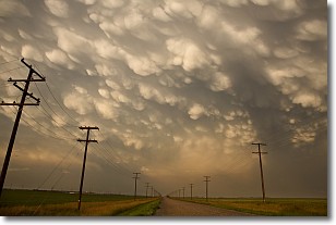
Weather Topic: What are Mammatus Clouds?
Home - Education - Cloud Types - Mammatus Clouds
 Next Topic: Nimbostratus Clouds
A mammatus cloud is a cloud with a unique feature which resembles
a web of pouches hanging along the base of the cloud.
In the United States, mammatus clouds tend to form in the warmer months, commonly
in the Midwest and eastern regions.
While they usually form at the bottom of a cumulonimbis cloud, they can also form
under altostratus, altocumulus, stratocumulus, and cirrus clouds. Mammatus clouds
warn that severe weather is close.
Next Topic: Nimbostratus Clouds
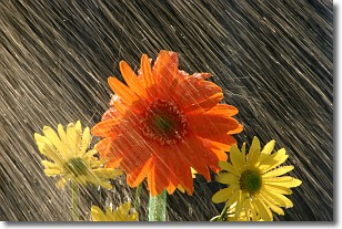
Weather Topic: What is Precipitation?
Home - Education - Precipitation - Precipitation
 Next Topic: Rain
Precipitation can refer to many different forms of water that
may fall from clouds. Precipitation occurs after a cloud has become saturated to
the point where its water particles are more dense than the air below the cloud.
In most cases, precipitation will reach the ground, but it is not uncommon for
precipitation to evaporate before it reaches the earth's surface.
When precipitation evaporates before it contacts the ground it is called Virga.
Graupel, hail, sleet, rain, drizzle, and snow are forms of precipitation, but fog
and mist are not considered precipitation because the water vapor which
constitutes them isn't dense enough to fall to the ground.
Next Topic: Rain
Current conditions powered by WeatherAPI.com


