Weather Alert in Alaska
Wind Advisory issued August 22 at 11:03PM AKDT until August 24 at 1:00AM AKDT by NWS Fairbanks AK
AREAS AFFECTED: South Slopes Of The Eastern Brooks Range; South Slopes Of The Central Brooks Range; Dalton Highway Summits; White Mountains and High Terrain South of the Yukon River; Upper Chena River Valley; Chatanika River Valley
DESCRIPTION: * WHAT...Southwest winds 20 to 30 mph with gusts up to 45 mph expected. The strongest winds are expected above 2000 feet elevation. * WHERE...Chatanika River Valley, Dalton Highway Summits, South Slopes Of The Central Brooks Range, South Slopes Of The Eastern Brooks Range, Upper Chena River Valley, and White Mountains and High Terrain South of the Yukon River. * WHEN...From 4 AM Saturday to 1 AM AKDT Sunday. * IMPACTS...Gusty winds will blow around unsecured objects and may cause tree damage resulting in a few power outages. * ADDITIONAL DETAILS...These strong winds usher in a prolonged period of rainy weather so hunters and recreationists are encouraged to prepare for rising water levels on rivers and their tributaries.
INSTRUCTION: Winds this strong can make driving difficult, especially for high profile vehicles. Use extra caution.
Want more detail? Get the Complete 7 Day and Night Detailed Forecast!
Current U.S. National Radar--Current
The Current National Weather Radar is shown below with a UTC Time (subtract 5 hours from UTC to get Eastern Time).

National Weather Forecast--Current
The Current National Weather Forecast and National Weather Map are shown below.

National Weather Forecast for Tomorrow
Tomorrow National Weather Forecast and Tomorrow National Weather Map are show below.

North America Water Vapor (Moisture)
This map shows recent moisture content over North America. Bright and colored areas show high moisture (ie, clouds); brown indicates very little moisture present; black indicates no moisture.

Weather Topic: What are Nimbostratus Clouds?
Home - Education - Cloud Types - Nimbostratus Clouds
 Next Topic: Precipitation
A nimbostratus cloud is similar to a stratus cloud in its formless,
smooth appearance. However, a nimbostratus cloud is darker than a stratus cloud,
because it is thicker.
Unlike a stratus cloud, a nimbostratus cloud typically brings with it the threat
of moderate to heavy precipitation. In some cases, the precipitation may evaporate
before reaching the ground, a phenomenon known as virga.
Next Topic: Precipitation
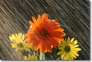
Weather Topic: What is Rain?
Home - Education - Precipitation - Rain
 Next Topic: Shelf Clouds
Precipitation in the form of water droplets is called rain.
Rain generally has a tendency to fall with less intensity over a greater period
of time, and when rainfall is more severe it is usually less sustained.
Rain is the most common form of precipitation and happens with greater frequency
depending on the season and regional influences. Cities have been shown to have
an observable effect on rainfall, due to an effect called the urban heat island.
Compared to upwind, monthly rainfall between twenty and forty miles downwind of
cities is 30% greater.
Next Topic: Shelf Clouds
Current conditions powered by WeatherAPI.com


