Weather Alert in Maine
Coastal Flood Advisory issued August 21 at 1:27PM EDT until August 23 at 1:00AM EDT by NWS Gray ME
AREAS AFFECTED: Coastal York; Coastal Cumberland; Sagadahoc; Lincoln; Knox; Coastal Rockingham
DESCRIPTION: * WHAT...For the High Rip Current Risk, a high risk of dangerous rip currents. For the High Surf Advisory, large breaking waves of 6 to 10 feet and a high risk of dangerous rip currents. For the Coastal Flood Advisory, minor coastal flooding and splash- over. * WHERE...In Maine, Coastal York, Coastal Cumberland, Sagadahoc, Lincoln and Knox Counties. In New Hampshire, Coastal Rockingham County. * WHEN...For the High Rip Current Risk, until 8 PM EDT this evening. For the High Surf Advisory, from 6 AM Friday to 8 PM EDT Saturday. For the Coastal Flood Advisory, from 10 PM Friday to 1 AM EDT Saturday. * IMPACTS...Flooding of lots, parks, and roads with only isolated road closures expected. Dangerous swimming and surfing conditions and localized beach erosion. Rip currents can sweep even the best swimmers away from shore into deeper water.
INSTRUCTION: If travel is required, allow extra time as some roads may be closed. Do not drive around barricades or through water of unknown depth. Take the necessary actions to protect flood-prone property. Inexperienced swimmers should remain out of the water due to dangerous surf conditions. Large waves can present a danger to people on rocks above the water. Stay away from rock outcrops along the shoreline exposed to ocean waves...as waves can easily sweep people into the cold ocean water.
Want more detail? Get the Complete 7 Day and Night Detailed Forecast!
Current U.S. National Radar--Current
The Current National Weather Radar is shown below with a UTC Time (subtract 5 hours from UTC to get Eastern Time).

National Weather Forecast--Current
The Current National Weather Forecast and National Weather Map are shown below.

National Weather Forecast for Tomorrow
Tomorrow National Weather Forecast and Tomorrow National Weather Map are show below.

North America Water Vapor (Moisture)
This map shows recent moisture content over North America. Bright and colored areas show high moisture (ie, clouds); brown indicates very little moisture present; black indicates no moisture.

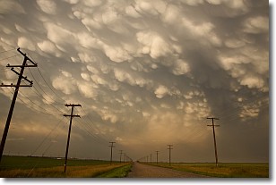
Weather Topic: What are Mammatus Clouds?
Home - Education - Cloud Types - Mammatus Clouds
 Next Topic: Nimbostratus Clouds
A mammatus cloud is a cloud with a unique feature which resembles
a web of pouches hanging along the base of the cloud.
In the United States, mammatus clouds tend to form in the warmer months, commonly
in the Midwest and eastern regions.
While they usually form at the bottom of a cumulonimbis cloud, they can also form
under altostratus, altocumulus, stratocumulus, and cirrus clouds. Mammatus clouds
warn that severe weather is close.
Next Topic: Nimbostratus Clouds
Weather Topic: What is Precipitation?
Home - Education - Precipitation - Precipitation
 Next Topic: Rain
Precipitation can refer to many different forms of water that
may fall from clouds. Precipitation occurs after a cloud has become saturated to
the point where its water particles are more dense than the air below the cloud.
In most cases, precipitation will reach the ground, but it is not uncommon for
precipitation to evaporate before it reaches the earth's surface.
When precipitation evaporates before it contacts the ground it is called Virga.
Graupel, hail, sleet, rain, drizzle, and snow are forms of precipitation, but fog
and mist are not considered precipitation because the water vapor which
constitutes them isn't dense enough to fall to the ground.
Next Topic: Rain
Current conditions powered by WeatherAPI.com


