Weather Alert in Minnesota
Flood Warning issued July 13 at 10:02PM CDT until July 20 at 7:00PM CDT by NWS Twin Cities/Chanhassen MN
AREAS AFFECTED: Chippewa, MN; Lac qui Parle, MN; Yellow Medicine, MN
DESCRIPTION: ...The Flood Warning continues for the following rivers in Minnesota... Minnesota River at Morton affecting Renville and Redwood Counties. ...The Flood Warning is extended for the following rivers in Minnesota... Minnesota River at Montevideo affecting Yellow Medicine, Chippewa and Lac qui Parle Counties. ...The Flood Warning is cancelled for the following rivers in Minnesota... Minnesota River at Granite Falls HWY 212 affecting Yellow Medicine, Chippewa and Renville Counties. .River levels continue to fall steadily as a lack of widespread rainfall continues through the next couple days before rain becomes more likely Tuesday into Wednesday. Granite Falls is exactly at minor flood stage as of 10pm, however it should drop below flood stage within the hour so electing to cancel it now instead of with the next forecast package in the morning. * WHAT...Minor flooding is occurring and minor flooding is forecast. * WHERE...Minnesota River at Montevideo. * WHEN...Until Sunday evening. * IMPACTS...At 14.0 feet, Low lying areas and some roads along the river begin flooding, along with some basements of houses along the river. * ADDITIONAL DETAILS... - At 900 PM CDT Sunday, the stage was 15.4 feet. - Recent Activity...The maximum river stage in the 24 hours ending at 900 PM CDT Sunday was 15.4 feet. - Forecast...The river is expected to fall below flood stage Sunday, July 20 and continue falling to 13.7 feet Sunday, July 20. - Flood stage is 14.0 feet. - Flood History...This crest compares to a previous crest of 15.3 feet on 03/03/1996.
INSTRUCTION: Turn around, don't drown when encountering flooded roads. Most flood deaths occur in vehicles. Caution is urged when walking near riverbanks.
Want more detail? Get the Complete 7 Day and Night Detailed Forecast!
Current U.S. National Radar--Current
The Current National Weather Radar is shown below with a UTC Time (subtract 5 hours from UTC to get Eastern Time).

National Weather Forecast--Current
The Current National Weather Forecast and National Weather Map are shown below.

National Weather Forecast for Tomorrow
Tomorrow National Weather Forecast and Tomorrow National Weather Map are show below.

North America Water Vapor (Moisture)
This map shows recent moisture content over North America. Bright and colored areas show high moisture (ie, clouds); brown indicates very little moisture present; black indicates no moisture.

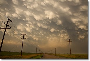
Weather Topic: What are Mammatus Clouds?
Home - Education - Cloud Types - Mammatus Clouds
 Next Topic: Nimbostratus Clouds
A mammatus cloud is a cloud with a unique feature which resembles
a web of pouches hanging along the base of the cloud.
In the United States, mammatus clouds tend to form in the warmer months, commonly
in the Midwest and eastern regions.
While they usually form at the bottom of a cumulonimbis cloud, they can also form
under altostratus, altocumulus, stratocumulus, and cirrus clouds. Mammatus clouds
warn that severe weather is close.
Next Topic: Nimbostratus Clouds
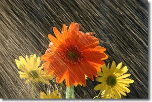
Weather Topic: What is Precipitation?
Home - Education - Precipitation - Precipitation
 Next Topic: Rain
Precipitation can refer to many different forms of water that
may fall from clouds. Precipitation occurs after a cloud has become saturated to
the point where its water particles are more dense than the air below the cloud.
In most cases, precipitation will reach the ground, but it is not uncommon for
precipitation to evaporate before it reaches the earth's surface.
When precipitation evaporates before it contacts the ground it is called Virga.
Graupel, hail, sleet, rain, drizzle, and snow are forms of precipitation, but fog
and mist are not considered precipitation because the water vapor which
constitutes them isn't dense enough to fall to the ground.
Next Topic: Rain
Current conditions powered by WeatherAPI.com


