Weather Alert in Kansas
Flood Warning issued August 28 at 5:33AM CDT until August 28 at 2:00PM CDT by NWS Wichita KS
AREAS AFFECTED: Chautauqua, KS; Montgomery, KS
DESCRIPTION: * WHAT...Flooding caused by excessive rainfall is possible. * WHERE...A portion of Southeast Kansas, including the following counties, Chautauqua and Montgomery. * WHEN...Until 200 PM CDT Thursday. * IMPACTS...Flooding of rivers, creeks, streams, city streets, and other low-lying and flood-prone locations is possible. * ADDITIONAL DETAILS... - At 533 AM CDT, Doppler radar indicated heavy rain due to thunderstorms. Up to 4 inches of rain has fallen overnight, with an additional 1 to 3 inches possible this morning. - Some locations that may experience flooding include... Coffeyville, Independence, Cherryvale, Caney, Sedan, Cedar Vale, Dearing, Elk City, Tyro, Peru, Liberty, Chautauqua, Havana, Elgin, Bolton, Sycamore, Niotaze, Hale, Independence Airport and Elk City Lake.
INSTRUCTION: Do not drive into flooded areas or go around barricades. Nearly two feet of water will carry most vehicles away. Turn around, don't drown. Be especially cautious at night when it is harder to recognize the dangers of flooding.
Want more detail? Get the Complete 7 Day and Night Detailed Forecast!
Current U.S. National Radar--Current
The Current National Weather Radar is shown below with a UTC Time (subtract 5 hours from UTC to get Eastern Time).

National Weather Forecast--Current
The Current National Weather Forecast and National Weather Map are shown below.

National Weather Forecast for Tomorrow
Tomorrow National Weather Forecast and Tomorrow National Weather Map are show below.

North America Water Vapor (Moisture)
This map shows recent moisture content over North America. Bright and colored areas show high moisture (ie, clouds); brown indicates very little moisture present; black indicates no moisture.

Weather Topic: What are Fractus Clouds?
Home - Education - Cloud Types - Fractus Clouds
 Next Topic: Freezing Rain
A fractus cloud (scud) is a fragmented, tattered cloud which has
likely been sheared off of another cloud. They are accessory clouds, meaning they
develop from parent clouds, and are named in a way which describes the original
cloud which contained them.
Fractus clouds which have originated from cumulus clouds are referred to as
cumulus fractus, while fractus clouds which have originated from stratus clouds
are referred to as stratus fractus. Under certain conditions a fractus cloud might
merge with another cloud, or develop into a cumulus cloud, but usually a
fractus cloud seen by itself will dissipate rapidly.
They are often observed on the leading and trailing edges of storm clouds,
and are a display of wind activity.
Next Topic: Freezing Rain
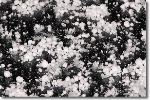
Weather Topic: What is Graupel?
Home - Education - Precipitation - Graupel
 Next Topic: Hail
Graupel is a form of precipitation that is created by atmospheric conditions
which cause supercooled water droplets to contact snow crystals and freeze to
their surface.
Sometimes known as soft hail or snow pellets, graupel is delicate and easily
destroyed by touch. Whereas hail usually falls during severe weather, graupel
doesn't require such conditions to form, and can form in mild precipitation
similar to situations which produce snowfall.
Next Topic: Hail
Current conditions powered by WeatherAPI.com


