Weather Alert in New Mexico
Fire Weather Watch issued February 16 at 4:37AM MST until February 18 at 6:00PM MST by NWS El Paso Tx/Santa Teresa NM
AREAS AFFECTED: Southwest Deserts and Lowlands; South Central Lowlands And Southern Rio Grande Valley; Capitan And Sacramento Mountains; El Paso; Hudspeth
DESCRIPTION: ...CRITICAL FIRE WEATHER CONDITIONS FOR MUCH OF SOUTHERN NEW MEXICO AND FAR WEST TEXAS WEDNESDAY... .A passing upper level trough will lead to increasing dryness and strong winds on Wednesday. Sustained winds will approach 25 to 35 MPH for much of the area, with gusts around 45 MPH common. The strongest winds will favor along and east of the Sacramento Mountains, where gusts could reach upwards of 60 MPH. This will combine with minimum relative humidity in the low double digits and teens in the afternoon, creating high fire danger. The National Weather Service in El Paso Tx/Santa Teresa has issued a Fire Weather Watch for critical fire weather conditions, which is in effect from Wednesday morning through Wednesday afternoon. * AFFECTED AREA...Fire Weather Zone 055 Texas Fire Weather Zone 055 El Paso County, Fire Weather Zone 056 Texas Fire Weather Zone 056 Hudspeth County, Fire Weather Zone 111 Southwest Deserts and Lowlands/Las Cruces BLM/GLZ, Fire Weather Zone 112 South Central Lowlands and Southern Rio Grande Valley/BLM/GLZ and Fire Weather Zone 113 Capitan and Sacramento Mountains/Lincoln NF/LNZ. * TIMING...11 AM to 6 PM Wednesday * WINDS...Southwest 25 to 35 mph with gusts up to 50 mph. * RELATIVE HUMIDITY...As low as 12 percent. * TEMPERATURES...Up to 69. * IMPACTS...Any fires that develop will likely spread rapidly. Outdoor burning is not recommended
INSTRUCTION: A Fire Weather Watch means that critical fire weather conditions are forecast to occur. Listen for later forecasts and possible Red Flag Warnings.
Want more detail? Get the Complete 7 Day and Night Detailed Forecast!
Current U.S. National Radar--Current
The Current National Weather Radar is shown below with a UTC Time (subtract 5 hours from UTC to get Eastern Time).

National Weather Forecast--Current
The Current National Weather Forecast and National Weather Map are shown below.

National Weather Forecast for Tomorrow
Tomorrow National Weather Forecast and Tomorrow National Weather Map are show below.

North America Water Vapor (Moisture)
This map shows recent moisture content over North America. Bright and colored areas show high moisture (ie, clouds); brown indicates very little moisture present; black indicates no moisture.

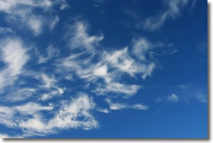
Weather Topic: What are Cirrostratus Clouds?
Home - Education - Cloud Types - Cirrostratus Clouds
 Next Topic: Cirrus Clouds
Cirrostratus clouds are high, thin clouds that form above
20,000 feet and are made mostly of ice crystals. They sometimes look like giant
feathers, horse tails, or curls of hair in the sky.
These clouds are pushed by the jet stream and can move at high speeds reaching
100 mph.
What do they indicate?
They indicate that a precipitation is likely within 24 hours.
Next Topic: Cirrus Clouds
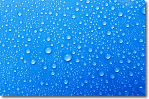
Weather Topic: What is Condensation?
Home - Education - Precipitation - Condensation
 Next Topic: Contrails
Condensation is the process which creates clouds, and therefore
it is a crucial process in the water cycle.
Condensation is the change of matter from a state of gas into a state of liquid,
and it happens because water molecules release heat into the atmosphere and
become organized into a more closely packed structure, what we might see as
water droplets.
Water is always present in the air around us as a vapor, but it's too small for
us to see. When water undergoes the process of condensation it becomes organized
into visible water droplets. You've probably seen condensation happen before on the
surface of a cold drink!
Next Topic: Contrails
Current conditions powered by WeatherAPI.com


