Weather Alert in Nebraska
Red Flag Warning issued February 16 at 12:12PM MST until February 17 at 6:00PM MST by NWS Cheyenne WY
AREAS AFFECTED: Pine Ridge/Nebraska National Forest; Box Butte/South Sioux/Niobrara River; Lower North Platte River Basin/Scottsbluff National Monument; Lodgepole Creek/Southern Nebraska Panhandle; Niobrara/Lower Elevations of Converse/Thunder Basin National Grassland; Middle North Platte River Basin/Niobrara and Converse High Plains; Laramie Foothills and High Plains; Laramie East High Plains; Bordeaux/Chugwater/Wheatland; Goshen/Middle-Lower North Platte River Basin
DESCRIPTION: The National Weather Service in Cheyenne has issued a Red Flag Warning, which is in effect from 5 AM to 6 PM MST Tuesday. The Fire Weather Watch has been upgraded. * AFFECTED AREA...Fire weather zone 434, 435, 436, 437, 417, 418, 430, 431, 432, and 433. * WIND...In the morning, southwest winds 10 to 20 MPH with gusts up to 30 MPH, becoming west 25 to 40 MPH with gusts up to 65 MPH possible in the late morning and afternoon. * HUMIDITY...10 to 20 percent. Poor humidity recoveries possible early in the morning. * HIGHEST THREAT...Just east of the Laramie Range across southeast Wyoming and the Interstate 25 corridor into the Nebraska panhandle. Poor humidity recoveries for this time of year are expected as winds quickly increase above criteria, as early as 600 AM. Strong winds, low relative humidity, and mild temperatures will lead to extremely critical fire weather conditions. * IMPACTS...Any fires that develop will likely spread rapidly. Outdoor burning is not recommended.
INSTRUCTION: A Red Flag Warning means that critical fire weather conditions are either occurring now, or will shortly. A combination of strong winds, low relative humidity, and warm temperatures can contribute to extreme fire behavior.
Want more detail? Get the Complete 7 Day and Night Detailed Forecast!
Current U.S. National Radar--Current
The Current National Weather Radar is shown below with a UTC Time (subtract 5 hours from UTC to get Eastern Time).

National Weather Forecast--Current
The Current National Weather Forecast and National Weather Map are shown below.

National Weather Forecast for Tomorrow
Tomorrow National Weather Forecast and Tomorrow National Weather Map are show below.

North America Water Vapor (Moisture)
This map shows recent moisture content over North America. Bright and colored areas show high moisture (ie, clouds); brown indicates very little moisture present; black indicates no moisture.

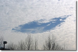
Weather Topic: What are Hole Punch Clouds?
Home - Education - Cloud Types - Hole Punch Clouds
 Next Topic: Mammatus Clouds
A hole punch cloud is an unusual occurrence when a disk-shaped
hole appears in a cirrostratus, cirrocumulus, or altocumulus cloud.
When part of the cloud forms ice crystals, water droplets in the surrounding area
of the cloud evaporate. The effect of this process produces a large elliptical
gap in the cloud. The hole punch cloud formation is rare, but it is not specific
to any geographic area.
Other names which have been used to describe this phenomena include fallstreak hole,
skypunch, and cloud hole.
Next Topic: Mammatus Clouds
Weather Topic: What are Nimbostratus Clouds?
Home - Education - Cloud Types - Nimbostratus Clouds
 Next Topic: Precipitation
A nimbostratus cloud is similar to a stratus cloud in its formless,
smooth appearance. However, a nimbostratus cloud is darker than a stratus cloud,
because it is thicker.
Unlike a stratus cloud, a nimbostratus cloud typically brings with it the threat
of moderate to heavy precipitation. In some cases, the precipitation may evaporate
before reaching the ground, a phenomenon known as virga.
Next Topic: Precipitation
Current conditions powered by WeatherAPI.com


