Weather Alert in California
Special Weather Statement issued August 23 at 10:40AM PDT by NWS Los Angeles/Oxnard CA
AREAS AFFECTED: Western San Gabriel Mountains and Highway 14 Corridor; Eastern San Gabriel Mountains; Western Antelope Valley Foothills; Eastern Antelope Valley Foothills; Antelope Valley
DESCRIPTION: At 1040 AM PDT, Doppler radar was tracking a cluster of strong thunderstorms was developing from near Llano to Saddleback Butte, moving northwest at 20 mph. HAZARD...Erratic wind gusts of 40 to 50 mph. SOURCE...Radar indicated. IMPACT...Gusty winds could knock down tree limbs and powerlines, produce blowing dust with low visibilities, as well as blow around unsecured objects. This strong thunderstorm will be near... Lake Los Angeles and Llano around 1040 AM PDT. Palmdale around 1050 AM PDT. Lancaster around 1110 AM PDT. Other locations impacted by this storm include Valyermo, Big Pines, Falling Springs, Angeles Crest Highway between Mount Waterman and Wrightwood, and Highway 138 between Llano and the San Bernardino County line.
INSTRUCTION: If outdoors, consider seeking shelter inside a building until the storm passes. Frequent cloud to ground lightning is occurring with this storm. Lightning can strike 10 miles away from a thunderstorm. Seek a safe shelter inside a building or vehicle. This storm may intensify. Continue to monitor the situation through local media sources and the National Weather Service.
Want more detail? Get the Complete 7 Day and Night Detailed Forecast!
Current U.S. National Radar--Current
The Current National Weather Radar is shown below with a UTC Time (subtract 5 hours from UTC to get Eastern Time).

National Weather Forecast--Current
The Current National Weather Forecast and National Weather Map are shown below.

National Weather Forecast for Tomorrow
Tomorrow National Weather Forecast and Tomorrow National Weather Map are show below.

North America Water Vapor (Moisture)
This map shows recent moisture content over North America. Bright and colored areas show high moisture (ie, clouds); brown indicates very little moisture present; black indicates no moisture.

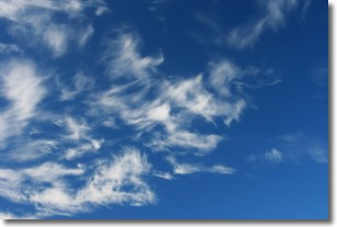
Weather Topic: What are Cirrostratus Clouds?
Home - Education - Cloud Types - Cirrostratus Clouds
 Next Topic: Cirrus Clouds
Cirrostratus clouds are high, thin clouds that form above
20,000 feet and are made mostly of ice crystals. They sometimes look like giant
feathers, horse tails, or curls of hair in the sky.
These clouds are pushed by the jet stream and can move at high speeds reaching
100 mph.
What do they indicate?
They indicate that a precipitation is likely within 24 hours.
Next Topic: Cirrus Clouds
Weather Topic: What is Condensation?
Home - Education - Precipitation - Condensation
 Next Topic: Contrails
Condensation is the process which creates clouds, and therefore
it is a crucial process in the water cycle.
Condensation is the change of matter from a state of gas into a state of liquid,
and it happens because water molecules release heat into the atmosphere and
become organized into a more closely packed structure, what we might see as
water droplets.
Water is always present in the air around us as a vapor, but it's too small for
us to see. When water undergoes the process of condensation it becomes organized
into visible water droplets. You've probably seen condensation happen before on the
surface of a cold drink!
Next Topic: Contrails
Current conditions powered by WeatherAPI.com


