Weather Alert in California
Cold Weather Advisory issued February 17 at 9:15PM PST until February 18 at 9:00AM PST by NWS San Francisco CA
AREAS AFFECTED: Santa Cruz Mountains; Santa Clara Valley Including San Jose
DESCRIPTION: * WHAT...Cold conditions with temperatures as low as 33 expected in the Santa Cruz Mountains. Cold conditions with temperatures as low as 34 expected in southern Santa Clara county and mid to upper 30s near San Jose. * WHERE...The Santa Cruz Mountains, and The Santa Clara Valley. * WHEN...Until 9 AM PST Wednesday. * IMPACTS...Cold conditions will be hazardous to sensitive populations such as unhoused individuals. Prolonged exposure to the cold conditions will lead to hypothermia for people, pets, and livestock. Cold conditions may damage or kill sensitive crops, plants, and vegetation if appropriate precautions are not taken.
INSTRUCTION: Ensure portable heaters are working properly and are used correctly to avoid sparking a fire indoors. Do not use generators or grills inside as carbon monoxide poisoning can result. Check with your local, city, or county officials for information on available warming centers. Be sure to dress in layers if outdoors. Make sure that pets and livestock have adequate food, unfrozen water, and warmth. Cover or tend to sensitive crops, plants, and vegetation.
Want more detail? Get the Complete 7 Day and Night Detailed Forecast!
Current U.S. National Radar--Current
The Current National Weather Radar is shown below with a UTC Time (subtract 5 hours from UTC to get Eastern Time).

National Weather Forecast--Current
The Current National Weather Forecast and National Weather Map are shown below.

National Weather Forecast for Tomorrow
Tomorrow National Weather Forecast and Tomorrow National Weather Map are show below.

North America Water Vapor (Moisture)
This map shows recent moisture content over North America. Bright and colored areas show high moisture (ie, clouds); brown indicates very little moisture present; black indicates no moisture.

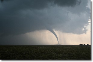
Weather Topic: What are Wall Clouds?
Home - Education - Cloud Types - Wall Clouds
 Next Topic: Altocumulus Clouds
A wall cloud forms underneath the base of a cumulonimbus cloud,
and can be a hotbed for deadly tornadoes.
Wall clouds are formed by air flowing into the cumulonimbus clouds, which can
result in the wall cloud descending from the base of the cumulonimbus cloud, or
rising fractus clouds which join to the base of the storm cloud as the wall cloud
takes shape.
Wall clouds can be very large, and in the Northern Hemisphere they generally
form at the southern edge of cumulonimbus clouds.
Next Topic: Altocumulus Clouds
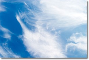
Weather Topic: What are Altostratus Clouds?
Home - Education - Cloud Types - Altostratus Clouds
 Next Topic: Cirrocumulus Clouds
Altostratus clouds form at mid to high-level altitudes
(between 2 and 7 km) and are created by a warm, stable air mass which causes
water vapor
to condense as it rise through the atmosphere. Usually altostratus clouds are
featureless sheets characterized by a uniform color.
In some cases, wind punching through the cloud formation may give it a waved
appearance, called altostratus undulatus. Altostratus clouds
are commonly seen with other cloud formations accompanying them.
Next Topic: Cirrocumulus Clouds
Current conditions powered by WeatherAPI.com


