Weather Alert in Minnesota
Winter Weather Advisory issued February 18 at 8:59PM CST until February 19 at 12:00AM CST by NWS Twin Cities/Chanhassen MN
AREAS AFFECTED: Douglas; Stevens; Pope; Stearns; Lac Qui Parle; Swift; Chippewa; Kandiyohi; Meeker
DESCRIPTION: ...BANDS OF HEAVY SNOW CONTINUE TO LIFT NORTH OVER SOUTHERN AND EASTERN MINNESOTA INTO WESTERN WISCONSIN THIS EVENING... .Snow continues across southern and eastern Minnesota into western Wisconsin. Bands of snow, some heavy at times, will result in travel impacts through this evening. A Winter Weather Advisory remains in effect south of I-94 and north and east of the Minnesota River in Minnesota. In addition, a Winter Weather Advisory remains in effect for portions of western Wisconsin, mainly surrounding the I-94 corridor as travel conditions have deteriorated. * WHAT...Snow. Additional snow accumulations up to 2 inches. Winds gusting as high as 30 mph. * WHERE...Kandiyohi, Meeker, Stearns, Chippewa, Douglas, Lac Qui Parle, Pope, Stevens, and Swift Counties. * WHEN...Until midnight CST tonight. * IMPACTS...Plan on slippery road conditions. * ADDITIONAL DETAILS...The combination of gusty winds and falling snow will reduce visibility and cause slippery travel.
INSTRUCTION: Slow down and use caution while traveling. Call 5 1 1 or visit 511mn.org for road conditions.
Want more detail? Get the Complete 7 Day and Night Detailed Forecast!
Current U.S. National Radar--Current
The Current National Weather Radar is shown below with a UTC Time (subtract 5 hours from UTC to get Eastern Time).

National Weather Forecast--Current
The Current National Weather Forecast and National Weather Map are shown below.

National Weather Forecast for Tomorrow
Tomorrow National Weather Forecast and Tomorrow National Weather Map are show below.

North America Water Vapor (Moisture)
This map shows recent moisture content over North America. Bright and colored areas show high moisture (ie, clouds); brown indicates very little moisture present; black indicates no moisture.

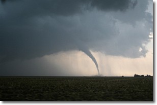
Weather Topic: What are Wall Clouds?
Home - Education - Cloud Types - Wall Clouds
 Next Topic: Altocumulus Clouds
A wall cloud forms underneath the base of a cumulonimbus cloud,
and can be a hotbed for deadly tornadoes.
Wall clouds are formed by air flowing into the cumulonimbus clouds, which can
result in the wall cloud descending from the base of the cumulonimbus cloud, or
rising fractus clouds which join to the base of the storm cloud as the wall cloud
takes shape.
Wall clouds can be very large, and in the Northern Hemisphere they generally
form at the southern edge of cumulonimbus clouds.
Next Topic: Altocumulus Clouds
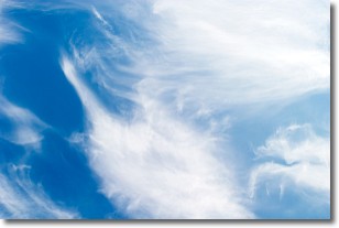
Weather Topic: What are Altostratus Clouds?
Home - Education - Cloud Types - Altostratus Clouds
 Next Topic: Cirrocumulus Clouds
Altostratus clouds form at mid to high-level altitudes
(between 2 and 7 km) and are created by a warm, stable air mass which causes
water vapor
to condense as it rise through the atmosphere. Usually altostratus clouds are
featureless sheets characterized by a uniform color.
In some cases, wind punching through the cloud formation may give it a waved
appearance, called altostratus undulatus. Altostratus clouds
are commonly seen with other cloud formations accompanying them.
Next Topic: Cirrocumulus Clouds
Current conditions powered by WeatherAPI.com


