Weather Alert in New Jersey
Coastal Flood Watch issued February 20 at 3:50PM EST until February 23 at 5:00AM EST by NWS Mount Holly NJ
AREAS AFFECTED: Middlesex; Western Monmouth; Eastern Monmouth
DESCRIPTION: * WHAT...One to two feet of inundation above ground level possible in low-lying areas near shorelines and tidal waterways. * WHERE...Middlesex, Western Monmouth and Eastern Monmouth. * WHEN...From Sunday evening through late Sunday night. * IMPACTS...At this level, widespread roadway flooding occurs in coastal and bayside communities and along inland tidal waterways. Many roads become impassable. Some damage to vulnerable structures may begin to occur. * ADDITIONAL DETAILS...Additional coastal flooding may linger into Monday's high tide cycles.
INSTRUCTION: A Coastal Flood Watch means that conditions favorable for flooding are expected to develop. Be prepared to begin taking appropriate action to protect life and property. Follow the recommendations of local emergency management officials. Be sure to check the latest forecast from time to time in case a warning is issued or any new information becomes available. Visit the National Water Prediction Service at https://water.noaa.gov/wfo/phi for additional water level and flood impact information for your local tide gauge.
Want more detail? Get the Complete 7 Day and Night Detailed Forecast!
Current U.S. National Radar--Current
The Current National Weather Radar is shown below with a UTC Time (subtract 5 hours from UTC to get Eastern Time).

National Weather Forecast--Current
The Current National Weather Forecast and National Weather Map are shown below.

National Weather Forecast for Tomorrow
Tomorrow National Weather Forecast and Tomorrow National Weather Map are show below.

North America Water Vapor (Moisture)
This map shows recent moisture content over North America. Bright and colored areas show high moisture (ie, clouds); brown indicates very little moisture present; black indicates no moisture.

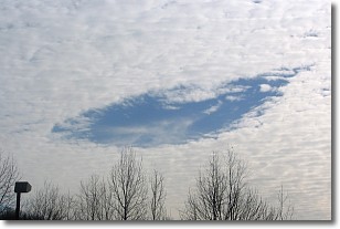
Weather Topic: What are Hole Punch Clouds?
Home - Education - Cloud Types - Hole Punch Clouds
 Next Topic: Mammatus Clouds
A hole punch cloud is an unusual occurrence when a disk-shaped
hole appears in a cirrostratus, cirrocumulus, or altocumulus cloud.
When part of the cloud forms ice crystals, water droplets in the surrounding area
of the cloud evaporate. The effect of this process produces a large elliptical
gap in the cloud. The hole punch cloud formation is rare, but it is not specific
to any geographic area.
Other names which have been used to describe this phenomena include fallstreak hole,
skypunch, and cloud hole.
Next Topic: Mammatus Clouds
Weather Topic: What are Nimbostratus Clouds?
Home - Education - Cloud Types - Nimbostratus Clouds
 Next Topic: Precipitation
A nimbostratus cloud is similar to a stratus cloud in its formless,
smooth appearance. However, a nimbostratus cloud is darker than a stratus cloud,
because it is thicker.
Unlike a stratus cloud, a nimbostratus cloud typically brings with it the threat
of moderate to heavy precipitation. In some cases, the precipitation may evaporate
before reaching the ground, a phenomenon known as virga.
Next Topic: Precipitation
Current conditions powered by WeatherAPI.com


