Weather Alert in Indiana
Winter Weather Advisory issued March 2 at 10:48AM EST until March 2 at 1:00PM EST by NWS Wilmington OH
AREAS AFFECTED: Ripley; Dearborn; Ohio; Switzerland; Carroll; Gallatin; Boone; Kenton; Campbell; Owen; Grant; Pendleton; Bracken; Robertson; Mason; Lewis; Hamilton; Clermont; Brown; Adams; Scioto
DESCRIPTION: * WHAT...Mixed precipitation. Additional snow accumulations less than a half inch and ice accumulations around a light glaze. * WHERE...Portions of southeast Indiana, northeast and northern Kentucky, and south central and southwest Ohio. * WHEN...Until 1 PM EST this afternoon. * IMPACTS...Roads, and especially bridges and overpasses, will likely become slick and hazardous. Plan on slippery road conditions.
INSTRUCTION: Slow down and use caution while traveling. In Indiana, visit 511in.org or call 1-800-261-7623 for the latest road information. In Kentucky, visit goky.ky.gov for the latest road information. In Ohio, visit ohgo.com for the latest road information. Be prepared for slippery roads. Slow down and use caution while driving. If you are going outside, watch your first few steps taken on stairs, sidewalks, and driveways. These surfaces could be icy and slippery, increasing your risk of a fall and injury.
Want more detail? Get the Complete 7 Day and Night Detailed Forecast!
Current U.S. National Radar--Current
The Current National Weather Radar is shown below with a UTC Time (subtract 5 hours from UTC to get Eastern Time).

National Weather Forecast--Current
The Current National Weather Forecast and National Weather Map are shown below.

National Weather Forecast for Tomorrow
Tomorrow National Weather Forecast and Tomorrow National Weather Map are show below.

North America Water Vapor (Moisture)
This map shows recent moisture content over North America. Bright and colored areas show high moisture (ie, clouds); brown indicates very little moisture present; black indicates no moisture.

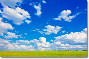
Weather Topic: What are Cumulus Clouds?
Home - Education - Cloud Types - Cumulus Clouds
 Next Topic: Drizzle
Cumulus clouds are fluffy and textured with rounded tops, and
may have flat bottoms. The border of a cumulus cloud
is clearly defined, and can have the appearance of cotton or cauliflower.
Cumulus clouds form at low altitudes (rarely above 2 km) but can grow very tall,
becoming cumulus congestus and possibly the even taller cumulonimbus clouds.
When cumulus clouds become taller, they have a greater chance of producing precipitation.
Next Topic: Drizzle
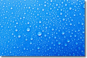
Weather Topic: What is Evaporation?
Home - Education - Precipitation - Evaporation
 Next Topic: Fog
Evaporation is the process which returns water from the earth
back to the atmosphere, and is another crucial process in the water cycle.
Evaporation is the transformation of liquid into gas, and it happens because
molecules are excited by the application of energy and turn into vapor.
In order for water to evaporate it has to be on the surface of a body of water.
Next Topic: Fog
Current conditions powered by WeatherAPI.com


