Weather Alert in Indiana
Flood Advisory issued March 4 at 9:48AM EST until March 4 at 1:00PM EST by NWS Wilmington OH
AREAS AFFECTED: Fayette, IN; Franklin, IN; Union, IN
DESCRIPTION: * WHAT...Flooding caused by excessive rainfall continues. * WHERE...The following counties, in east central Indiana, Fayette and Union. In southeast Indiana, Franklin. * WHEN...Until 100 PM EST. * IMPACTS...Minor flooding in low-lying and poor drainage areas. Some low-water crossings may become impassable. * ADDITIONAL DETAILS... - At 948 AM EST, local law enforcement reported minor flooding in the advisory area. Between 2 and 3.5 inches of rain have fallen. Flooding impacts will slowly improve, but no significant additional rainfall is expected until this evening and overnight tonight. - Some locations that may experience flooding include... Connersville, Batesville, Brookville, Liberty, West College Corner, Oldenburg, Glenwood, Lake Santee, Salem, Waterloo, Blooming Grove, Columbia, Metamora, Bunker Hill, Brownsville, St. Leon, Laurel, Scipio, College Corner and Cedar Grove.
INSTRUCTION: Be aware of your surroundings and do not drive on flooded roads. To report flooding, go to our website at weather.gov/iln and submit your report via social media, when you can do so safely.
Want more detail? Get the Complete 7 Day and Night Detailed Forecast!
Current U.S. National Radar--Current
The Current National Weather Radar is shown below with a UTC Time (subtract 5 hours from UTC to get Eastern Time).

National Weather Forecast--Current
The Current National Weather Forecast and National Weather Map are shown below.

National Weather Forecast for Tomorrow
Tomorrow National Weather Forecast and Tomorrow National Weather Map are show below.

North America Water Vapor (Moisture)
This map shows recent moisture content over North America. Bright and colored areas show high moisture (ie, clouds); brown indicates very little moisture present; black indicates no moisture.

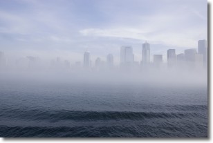
Weather Topic: What is Fog?
Home - Education - Cloud Types - Fog
 Next Topic: Fractus Clouds
Fog is technically a type of stratus cloud, which lies along the
ground and obscures visibility.
It is usually created when humidity in the air condenses into tiny water droplets.
Because of this, some places are more prone to foggy weather, such as regions
close to a body of water.
Fog is similar to mist; both are the appearance of water droplets suspended in
the air, but fog is the term applied to the condition when visibility is less than 1 km.
Next Topic: Fractus Clouds
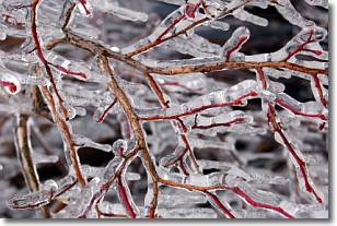
Weather Topic: What is Freezing Rain?
Home - Education - Precipitation - Freezing Rain
 Next Topic: Graupel
Freezing rain is a condition where precipitation which has fallen in the form of
water droplets reaches temperatures which are below freezing and freezes upon
coming into contact
with surface objects. The result of this precipitation is a glaze of ice which
can be damaging to plants and man-made structures. A severe onset of freezing
rain which results in a very thick glaze of ice is known as an ice storm.
Next Topic: Graupel
Current conditions powered by WeatherAPI.com


