Weather Alert in Colorado
Flood Watch issued August 25 at 3:06AM MDT until August 26 at 12:00AM MDT by NWS Pueblo CO
AREAS AFFECTED: Northwestern Fremont County Above 8500Ft; Teller County/Rampart Range above 7500fT/Pike's Peak Between 7500 And 11000 Ft; Pikes Peak above 11000 Ft; Canon City Vicinity/Eastern Fremont County; Northern El Paso County/Monument Ridge/Rampart Range Below 7500 Ft; Colorado Springs Vicinity/Southern El Paso County/Rampart Range Below 7400 Ft; Pueblo Vicinity/Pueblo County Below 6300 Feet; Trinidad Vicinity/Western Las Animas County Below 7500 Ft
DESCRIPTION: * WHAT...Flash flooding caused by excessive rainfall continues to be possible. * WHERE...Portions of central, east central, and southeast Colorado, including the following areas, in central Colorado, Canon City Vicinity/Eastern Fremont County, Northwestern Fremont County Above 8500 Feet, Pikes Peak Above 11000 Feet and Teller County/Rampart Range Above 7500 Feet/Pikes Peak Between 7500 And 11000 Feet. In east central Colorado, Colorado Springs Vicinity/Southern El Paso County/Rampart Range Below 7400 Feet and Northern El Paso County/Monument Ridge/Rampart Range Below 7500 Feet. In southeast Colorado, Pueblo Vicinity/Pueblo County Below 6300 Feet and Trinidad Vicinity/Western Las Animas County Below 7500 Feet. * WHEN...From noon MDT today through this evening. * IMPACTS...Excessive runoff may result in flooding of rivers, creeks, streams, and other low-lying and flood-prone locations. * ADDITIONAL DETAILS... - http://www.weather.gov/safety/flood
INSTRUCTION: You should monitor later forecasts and be prepared to take action should Flash Flood Warnings be issued.
Want more detail? Get the Complete 7 Day and Night Detailed Forecast!
Current U.S. National Radar--Current
The Current National Weather Radar is shown below with a UTC Time (subtract 5 hours from UTC to get Eastern Time).

National Weather Forecast--Current
The Current National Weather Forecast and National Weather Map are shown below.

National Weather Forecast for Tomorrow
Tomorrow National Weather Forecast and Tomorrow National Weather Map are show below.

North America Water Vapor (Moisture)
This map shows recent moisture content over North America. Bright and colored areas show high moisture (ie, clouds); brown indicates very little moisture present; black indicates no moisture.

Weather Topic: What is Hail?
Home - Education - Precipitation - Hail
 Next Topic: Hole Punch Clouds
Hail is a form of precipitation which is recognized by large solid balls or
clumps of ice. Hail is created by thunderstorm clouds with strong updrafts of wind.
As the hailstones remain in the updraft, ice is deposited onto them until their
weight becomes heavy enough for them to fall to the earth's surface.
Hail storms can cause significant damage to crops, aircrafts, and man-made structures,
despite the fact that the duration is usually less than ten minutes.
Next Topic: Hole Punch Clouds
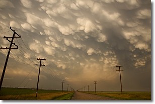
Weather Topic: What are Mammatus Clouds?
Home - Education - Cloud Types - Mammatus Clouds
 Next Topic: Nimbostratus Clouds
A mammatus cloud is a cloud with a unique feature which resembles
a web of pouches hanging along the base of the cloud.
In the United States, mammatus clouds tend to form in the warmer months, commonly
in the Midwest and eastern regions.
While they usually form at the bottom of a cumulonimbis cloud, they can also form
under altostratus, altocumulus, stratocumulus, and cirrus clouds. Mammatus clouds
warn that severe weather is close.
Next Topic: Nimbostratus Clouds
Current conditions powered by WeatherAPI.com


