Weather Alert in Illinois
Flood Warning issued April 3 at 12:49AM EDT by NWS Indianapolis IN
AREAS AFFECTED: Crawford, IL; Lawrence, IL; Knox, IN; Sullivan, IN
DESCRIPTION: ...The Flood Warning continues for the following rivers in Indiana and Illinois... Wabash River from Lafayette to Hutsonville. .Multiple rounds of rainfall will bring minor lowland flooding to the Wabash River basin that could hang around through much of next week. The current river forecasts include around an inch of rainfall through Saturday morning, but do not include rainfall from Saturday through Sunday. Higher rainfall amounts in the Wabash basin could increase crests or lengthen the amount of time in flood. * WHAT...Minor flooding is forecast. * WHERE...Wabash River at Hutsonville Legacy Power Plant Site. * WHEN...From this evening until further notice. * IMPACTS...At 22.0 feet, River cabins become isolated. Basement flooding begins in Hutsonville. Extensive agricultural flooding is in progress. Higher Illinois rural roads in eastern Clark and Crawford counties flood. * ADDITIONAL DETAILS... - There is no current observed data. - Forecast...The river is expected to rise above flood stage this evening and continue rising to a crest of 21.9 feet Friday, April 10. - Flood stage is 16.0 feet. - http://www.weather.gov/safety/flood
INSTRUCTION: Motorists should not attempt to drive around barricades or drive cars through flooded areas. Be especially cautious at night when it is harder to recognize the dangers of flooding. Turn around, don't drown when encountering flooded roads. Most flood deaths occur in vehicles. Additional information is available at www.weather.gov/ind. The next statement should be issued this afternoon by around 145 PM EDT /1245 PM CDT/.
Want more detail? Get the Complete 7 Day and Night Detailed Forecast!
Current U.S. National Radar--Current
The Current National Weather Radar is shown below with a UTC Time (subtract 5 hours from UTC to get Eastern Time).

National Weather Forecast--Current
The Current National Weather Forecast and National Weather Map are shown below.

National Weather Forecast for Tomorrow
Tomorrow National Weather Forecast and Tomorrow National Weather Map are show below.

North America Water Vapor (Moisture)
This map shows recent moisture content over North America. Bright and colored areas show high moisture (ie, clouds); brown indicates very little moisture present; black indicates no moisture.

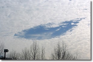
Weather Topic: What are Hole Punch Clouds?
Home - Education - Cloud Types - Hole Punch Clouds
 Next Topic: Mammatus Clouds
A hole punch cloud is an unusual occurrence when a disk-shaped
hole appears in a cirrostratus, cirrocumulus, or altocumulus cloud.
When part of the cloud forms ice crystals, water droplets in the surrounding area
of the cloud evaporate. The effect of this process produces a large elliptical
gap in the cloud. The hole punch cloud formation is rare, but it is not specific
to any geographic area.
Other names which have been used to describe this phenomena include fallstreak hole,
skypunch, and cloud hole.
Next Topic: Mammatus Clouds
Weather Topic: What are Nimbostratus Clouds?
Home - Education - Cloud Types - Nimbostratus Clouds
 Next Topic: Precipitation
A nimbostratus cloud is similar to a stratus cloud in its formless,
smooth appearance. However, a nimbostratus cloud is darker than a stratus cloud,
because it is thicker.
Unlike a stratus cloud, a nimbostratus cloud typically brings with it the threat
of moderate to heavy precipitation. In some cases, the precipitation may evaporate
before reaching the ground, a phenomenon known as virga.
Next Topic: Precipitation
Current conditions powered by WeatherAPI.com


