Weather Alert in Indiana
Special Weather Statement issued March 1 at 2:59PM EST by NWS Louisville KY
AREAS AFFECTED: Orange; Washington; Scott; Jefferson; Dubois; Crawford; Perry; Harrison; Floyd; Clark; Hancock; Breckinridge; Meade; Hardin; Bullitt; Jefferson; Oldham; Trimble; Henry; Shelby; Franklin; Scott; Harrison; Spencer; Anderson; Woodford; Fayette; Bourbon; Nicholas; Nelson; Washington; Mercer; Jessamine; Clark; Garrard; Madison
DESCRIPTION: Late tonight, a weather disturbance will move into the region from the west. Precipitation will likely start off as snow across much of southern Indiana, but a wintry mix of snow, sleet, and freezing rain will be possible, mainly in areas north of a line from Hawesville to Elizabethtown to Richmond. A slushy accumulation of up to one inch will be possible in areas along and north of the I-64 corridor. Just to the south of the I-64 corridor a light coating of snow with a light glaze of ice will be possible. While surface temperatures will be right at freezing, some slick travel will be possible during the Monday morning commute, especially on bridges and overpasses. Stay up to date with the latest forecasts and allow extra time to reach your destination Monday morning. Stay tuned to NOAA Weather Radio and your local media for the latest forecast updates.
INSTRUCTION: N/A
Want more detail? Get the Complete 7 Day and Night Detailed Forecast!
Current U.S. National Radar--Current
The Current National Weather Radar is shown below with a UTC Time (subtract 5 hours from UTC to get Eastern Time).

National Weather Forecast--Current
The Current National Weather Forecast and National Weather Map are shown below.

National Weather Forecast for Tomorrow
Tomorrow National Weather Forecast and Tomorrow National Weather Map are show below.

North America Water Vapor (Moisture)
This map shows recent moisture content over North America. Bright and colored areas show high moisture (ie, clouds); brown indicates very little moisture present; black indicates no moisture.

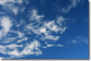
Weather Topic: What are Altostratus Clouds?
Home - Education - Cloud Types - Altostratus Clouds
 Next Topic: Cirrocumulus Clouds
Altostratus clouds form at mid to high-level altitudes
(between 2 and 7 km) and are created by a warm, stable air mass which causes
water vapor
to condense as it rise through the atmosphere. Usually altostratus clouds are
featureless sheets characterized by a uniform color.
In some cases, wind punching through the cloud formation may give it a waved
appearance, called altostratus undulatus. Altostratus clouds
are commonly seen with other cloud formations accompanying them.
Next Topic: Cirrocumulus Clouds
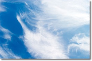
Weather Topic: What are Cirrostratus Clouds?
Home - Education - Cloud Types - Cirrostratus Clouds
 Next Topic: Cirrus Clouds
Cirrostratus clouds are high, thin clouds that form above
20,000 feet and are made mostly of ice crystals. They sometimes look like giant
feathers, horse tails, or curls of hair in the sky.
These clouds are pushed by the jet stream and can move at high speeds reaching
100 mph.
What do they indicate?
They indicate that a precipitation is likely within 24 hours.
Next Topic: Cirrus Clouds
Current conditions powered by WeatherAPI.com


