Weather Alert in Tennessee
Severe Thunderstorm Watch issued September 5 at 5:43PM EDT until September 6 at 1:00AM EDT by NWS Morristown TN
AREAS AFFECTED: Campbell, TN; Claiborne, TN; Hancock, TN; Morgan, TN; Scott, TN; Lee, VA
DESCRIPTION: THE NATIONAL WEATHER SERVICE HAS ISSUED SEVERE THUNDERSTORM WATCH 606 IN EFFECT UNTIL 1 AM EDT SATURDAY FOR THE FOLLOWING AREAS IN TENNESSEE THIS WATCH INCLUDES 5 COUNTIES IN EAST TENNESSEE CAMPBELL CLAIBORNE HANCOCK MORGAN SCOTT IN VIRGINIA THIS WATCH INCLUDES 1 COUNTY IN SOUTHWEST VIRGINIA LEE THIS INCLUDES THE CITIES OF ARTHUR, BIG SOUTH FORK NATIONAL, CARYVILLE, CLAIRFIELD, ELGIN, ELK VALLEY, EVANSTON, FINCASTLE, HARROGATE-SHAWANEE, HIGH POINT, HOWARD QUARTER, HUNTSVILLE, JELLICO, KYLES FORD, LA FOLLETTE, LONE MOUNTAIN, NORMA, ONEIDA, PETROS, PINE ORCHARD, ROSE HILL, ROYAL BLUE, SANDLICK, SLICK ROCK, SMOKEY JUNCTION, SNEEDVILLE, SPRINGDALE, TREADWAY, AND WHITE OAK.
INSTRUCTION: N/A
Want more detail? Get the Complete 7 Day and Night Detailed Forecast!
Current U.S. National Radar--Current
The Current National Weather Radar is shown below with a UTC Time (subtract 5 hours from UTC to get Eastern Time).

National Weather Forecast--Current
The Current National Weather Forecast and National Weather Map are shown below.

National Weather Forecast for Tomorrow
Tomorrow National Weather Forecast and Tomorrow National Weather Map are show below.

North America Water Vapor (Moisture)
This map shows recent moisture content over North America. Bright and colored areas show high moisture (ie, clouds); brown indicates very little moisture present; black indicates no moisture.

Weather Topic: What are Stratus Clouds?
Home - Education - Cloud Types - Stratus Clouds
 Next Topic: Wall Clouds
Stratus clouds are similar to altostratus clouds, but form at a
lower altitude and are identified by their fog-like appearance, lacking the
distinguishing features of most clouds.
Stratus clouds are wider than most clouds, and their base has a smooth, uniform
look which is lighter in color than a nimbostratus cloud.
The presence of a stratus cloud indicates the possibility of minor precipitation,
such as drizzle, but heavier precipitation does not typically arrive in the form
of a stratus cloud.
Next Topic: Wall Clouds
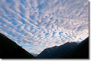
Weather Topic: What are Altocumulus Clouds?
Home - Education - Cloud Types - Altocumulus Clouds
 Next Topic: Altostratus Clouds
Similar to cirrocumulus clouds, altocumulus clouds are
characterized by cloud patches. They are distinguished by larger cloudlets
than cirrocumulus clouds but are still smaller than stratocumulus clouds.
Altocumulus clouds most commonly form in middle altitudes (between 2 and 5 km)
and may resemble, at times, the shape of a flying saucer.
These uncommon formations, called altocumulus lenticularis, are created by uplift
in the atmosphere and are most often seen in close proximity to mountains.
Next Topic: Altostratus Clouds
Current conditions powered by WeatherAPI.com


