Weather Alert in Indiana
Flood Warning issued March 3 at 12:35PM EST until March 11 at 8:37AM EDT by NWS Indianapolis IN
AREAS AFFECTED: Daviess, IN; Greene, IN; Knox, IN
DESCRIPTION: ...The National Weather Service in Indianapolis IN has issued a Flood Warning for the following rivers in Indiana... East Fork White River at Seymour. White River at Elliston. White River at Newberry. .Multiple rounds of rainfall over central Indiana over the next several days are expected to bring at least minor flooding on area rivers and streams. Flooding is expected to develop along portions of the East Fork White and lower White basins over the next 48 hours. Forecast crests issued today include rainfall amounts of 3 to 4 inches over large portions of the East Fork White and lower White basins from this morning through Friday morning, but additional rainfall expected from Friday onward will likely increase crests and lengthen the amount of time in flood. * WHAT...Minor flooding is forecast. * WHERE...White River at Elliston. * WHEN...From Wednesday evening to Wednesday, March 11. * IMPACTS...At 24.0 feet, State Road 157 between Worthington and Bloomfield begins to flood. County Road 175 south of Bloomfield floods. County Road 100 W between CR 110 N and SR 67 (Jefferson Twp), CR 850 N between SR 48 and SR 157 (Jefferson Twp), CR 250 W between SR 54 and CR 250 N (Fairplay Twp), CR 200 W between CR 157 S and CR 260 S (Washington Twp), CR 100 W between CR 100 S and CR 260 S (Washington Twp), and CR 100 W between CR 250 W and the White River affected by high water. * ADDITIONAL DETAILS... - At 8:00 AM EST Tuesday the stage was 8.8 feet. - Forecast...The river is expected to rise above flood stage tomorrow evening to a crest of 24.0 feet Saturday morning. - Flood stage is 18.0 feet. - http://www.weather.gov/safety/flood
INSTRUCTION: Motorists should not attempt to drive around barricades or drive cars through flooded areas. Additional information is available at www.weather.gov/ind. The next statement should be issued late tonight by around 345 AM EST.
Want more detail? Get the Complete 7 Day and Night Detailed Forecast!
Current U.S. National Radar--Current
The Current National Weather Radar is shown below with a UTC Time (subtract 5 hours from UTC to get Eastern Time).

National Weather Forecast--Current
The Current National Weather Forecast and National Weather Map are shown below.

National Weather Forecast for Tomorrow
Tomorrow National Weather Forecast and Tomorrow National Weather Map are show below.

North America Water Vapor (Moisture)
This map shows recent moisture content over North America. Bright and colored areas show high moisture (ie, clouds); brown indicates very little moisture present; black indicates no moisture.

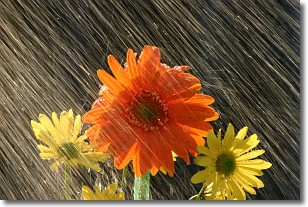
Weather Topic: What is Rain?
Home - Education - Precipitation - Rain
 Next Topic: Shelf Clouds
Precipitation in the form of water droplets is called rain.
Rain generally has a tendency to fall with less intensity over a greater period
of time, and when rainfall is more severe it is usually less sustained.
Rain is the most common form of precipitation and happens with greater frequency
depending on the season and regional influences. Cities have been shown to have
an observable effect on rainfall, due to an effect called the urban heat island.
Compared to upwind, monthly rainfall between twenty and forty miles downwind of
cities is 30% greater.
Next Topic: Shelf Clouds
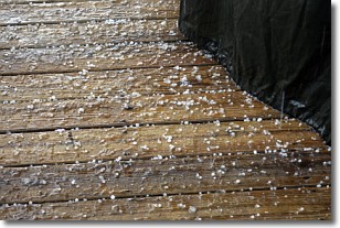
Weather Topic: What is Sleet?
Home - Education - Precipitation - Sleet
 Next Topic: Snow
Sleet is a form of precipitation in which small ice pellets are the primary
components. These ice pellets are smaller and more translucent than hailstones,
and harder than graupel. Sleet is caused by specific atmospheric conditions and
therefore typically doesn't last for extended periods of time.
The condition which leads to sleet formation requires a warmer body of air to be
wedged in between two sub-freezing bodies of air. When snow falls through a warmer
layer of air it melts, and as it falls through the next sub-freezing body of air
it freezes again, forming ice pellets known as sleet. In some cases, water
droplets don't have time to freeze before reaching the surface and the result is
freezing rain.
Next Topic: Snow
Current conditions powered by WeatherAPI.com


