Weather Alert in Indiana
Flood Warning issued March 3 at 12:35PM EST until March 10 at 6:00PM EDT by NWS Indianapolis IN
AREAS AFFECTED: Daviess, IN; Greene, IN; Knox, IN
DESCRIPTION: ...The National Weather Service in Indianapolis IN has issued a Flood Warning for the following rivers in Indiana... East Fork White River at Seymour. White River at Elliston. White River at Newberry. .Multiple rounds of rainfall over central Indiana over the next several days are expected to bring at least minor flooding on area rivers and streams. Flooding is expected to develop along portions of the East Fork White and lower White basins over the next 48 hours. Forecast crests issued today include rainfall amounts of 3 to 4 inches over large portions of the East Fork White and lower White basins from this morning through Friday morning, but additional rainfall expected from Friday onward will likely increase crests and lengthen the amount of time in flood. * WHAT...Minor flooding is forecast. * WHERE...White River at Newberry. * WHEN...From Thursday morning to Tuesday, March 10. * IMPACTS...At 17.0 feet, Flood waters block access and begins to surround about 5 to 10 river cabins on south side of the river just southwest of Newberry. * ADDITIONAL DETAILS... - At 11:30 AM EST Tuesday the stage was 2.4 feet. - Forecast...The river is expected to rise above flood stage Thursday morning to a crest of 17.5 feet Saturday morning. - Flood stage is 13.0 feet. - http://www.weather.gov/safety/flood
INSTRUCTION: Motorists should not attempt to drive around barricades or drive cars through flooded areas. Additional information is available at www.weather.gov/ind. The next statement should be issued late tonight by around 345 AM EST.
Want more detail? Get the Complete 7 Day and Night Detailed Forecast!
Current U.S. National Radar--Current
The Current National Weather Radar is shown below with a UTC Time (subtract 5 hours from UTC to get Eastern Time).

National Weather Forecast--Current
The Current National Weather Forecast and National Weather Map are shown below.

National Weather Forecast for Tomorrow
Tomorrow National Weather Forecast and Tomorrow National Weather Map are show below.

North America Water Vapor (Moisture)
This map shows recent moisture content over North America. Bright and colored areas show high moisture (ie, clouds); brown indicates very little moisture present; black indicates no moisture.

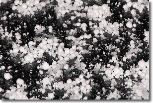
Weather Topic: What is Graupel?
Home - Education - Precipitation - Graupel
 Next Topic: Hail
Graupel is a form of precipitation that is created by atmospheric conditions
which cause supercooled water droplets to contact snow crystals and freeze to
their surface.
Sometimes known as soft hail or snow pellets, graupel is delicate and easily
destroyed by touch. Whereas hail usually falls during severe weather, graupel
doesn't require such conditions to form, and can form in mild precipitation
similar to situations which produce snowfall.
Next Topic: Hail
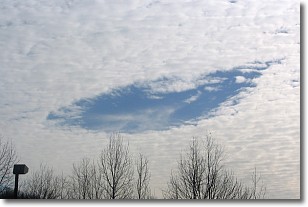
Weather Topic: What are Hole Punch Clouds?
Home - Education - Cloud Types - Hole Punch Clouds
 Next Topic: Mammatus Clouds
A hole punch cloud is an unusual occurrence when a disk-shaped
hole appears in a cirrostratus, cirrocumulus, or altocumulus cloud.
When part of the cloud forms ice crystals, water droplets in the surrounding area
of the cloud evaporate. The effect of this process produces a large elliptical
gap in the cloud. The hole punch cloud formation is rare, but it is not specific
to any geographic area.
Other names which have been used to describe this phenomena include fallstreak hole,
skypunch, and cloud hole.
Next Topic: Mammatus Clouds
Current conditions powered by WeatherAPI.com


