Weather Alert in Alaska
Winter Storm Warning issued February 18 at 2:52PM AKST until February 20 at 7:00AM AKST by NWS Fairbanks AK
AREAS AFFECTED: White Mountains and High Terrain South of the Yukon River; Upper Chena River Valley; Tanana Flats; Eielson AFB and Salcha; Goldstream Valley and Nenana Hills; Chatanika River Valley; Two Rivers; Fairbanks Metro Area; Nenana; Central Interior
DESCRIPTION: * WHAT...Heavy snow. Additional snow accumulations of 2 to 4 inches. * WHERE...Central Interior, Chatanika River Valley, Eielson AFB and Salcha, Fairbanks Metro Area, Goldstream Valley and Nenana Hills, Nenana, Tanana Flats, Two Rivers, Upper Chena River Valley, and White Mountains and High Terrain South of the Yukon River. * WHEN...Until 7 AM AKST Friday. * IMPACTS...Travel may be impacted. The hazardous conditions could impact the Wednesday evening and Thursday morning commutes. * ADDITIONAL DETAILS...Widespread accumulating snow will be ending from west to east Wednesday evening with a break in the snowfall expected tonight. Another round of snow showers arrives early Thursday morning with an additional 2 to 4 inches possible under heavier snow showers. Higher overall snowfall amounts expected north and west of Fairbanks.
INSTRUCTION: If you must travel, keep an extra flashlight, food, and water in your vehicle in case of an emergency. Visit 511.alaska.gov or call 5 1 1 for the latest road conditions.
Want more detail? Get the Complete 7 Day and Night Detailed Forecast!
Current U.S. National Radar--Current
The Current National Weather Radar is shown below with a UTC Time (subtract 5 hours from UTC to get Eastern Time).

National Weather Forecast--Current
The Current National Weather Forecast and National Weather Map are shown below.

National Weather Forecast for Tomorrow
Tomorrow National Weather Forecast and Tomorrow National Weather Map are show below.

North America Water Vapor (Moisture)
This map shows recent moisture content over North America. Bright and colored areas show high moisture (ie, clouds); brown indicates very little moisture present; black indicates no moisture.

Weather Topic: What is Hail?
Home - Education - Precipitation - Hail
 Next Topic: Hole Punch Clouds
Hail is a form of precipitation which is recognized by large solid balls or
clumps of ice. Hail is created by thunderstorm clouds with strong updrafts of wind.
As the hailstones remain in the updraft, ice is deposited onto them until their
weight becomes heavy enough for them to fall to the earth's surface.
Hail storms can cause significant damage to crops, aircrafts, and man-made structures,
despite the fact that the duration is usually less than ten minutes.
Next Topic: Hole Punch Clouds
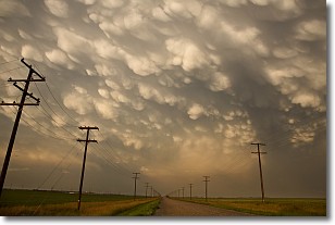
Weather Topic: What are Mammatus Clouds?
Home - Education - Cloud Types - Mammatus Clouds
 Next Topic: Nimbostratus Clouds
A mammatus cloud is a cloud with a unique feature which resembles
a web of pouches hanging along the base of the cloud.
In the United States, mammatus clouds tend to form in the warmer months, commonly
in the Midwest and eastern regions.
While they usually form at the bottom of a cumulonimbis cloud, they can also form
under altostratus, altocumulus, stratocumulus, and cirrus clouds. Mammatus clouds
warn that severe weather is close.
Next Topic: Nimbostratus Clouds
Current conditions powered by WeatherAPI.com


