Weather Alert in Michigan
Hydrologic Outlook issued February 17 at 9:43AM EST by NWS Grand Rapids MI
AREAS AFFECTED: Allegan, MI; Barry, MI; Calhoun, MI; Clinton, MI; Eaton, MI; Ingham, MI; Ionia, MI; Jackson, MI; Kalamazoo, MI; Kent, MI; Muskegon, MI; Ottawa, MI; Van Buren, MI
DESCRIPTION: ESFGRR Steady melting of snow and ice over the last week has begun to cause rivers to rise across the area. Several chances for rain this week will add to these rises. Based on current expected rainfall, no significant flooding is expected on West Michigan rivers, though typical spring water level rises within the river channels will happen. Meanwhile, river ice has weakened significantly over the last week, and as water levels rise any remaining ice will likely be broken and start to move downstream. This creates the possibility for formation of a few ice jams. Ice jams tend to form in the same places repeatedly, so special attention should be paid in the Comstock Park (Kent County) area as well as the Robinson Township (Ottawa County) area along the Grand River. Anyone living or working near West Michigan rivers should pay extra attention this week as water levels rise. Have a plan to monitor and respond if flooding develops unexpectedly. Monitor the latest conditions at https://water.noaa.gov
INSTRUCTION: N/A
Want more detail? Get the Complete 7 Day and Night Detailed Forecast!
Current U.S. National Radar--Current
The Current National Weather Radar is shown below with a UTC Time (subtract 5 hours from UTC to get Eastern Time).

National Weather Forecast--Current
The Current National Weather Forecast and National Weather Map are shown below.

National Weather Forecast for Tomorrow
Tomorrow National Weather Forecast and Tomorrow National Weather Map are show below.

North America Water Vapor (Moisture)
This map shows recent moisture content over North America. Bright and colored areas show high moisture (ie, clouds); brown indicates very little moisture present; black indicates no moisture.

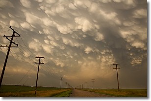
Weather Topic: What are Mammatus Clouds?
Home - Education - Cloud Types - Mammatus Clouds
 Next Topic: Nimbostratus Clouds
A mammatus cloud is a cloud with a unique feature which resembles
a web of pouches hanging along the base of the cloud.
In the United States, mammatus clouds tend to form in the warmer months, commonly
in the Midwest and eastern regions.
While they usually form at the bottom of a cumulonimbis cloud, they can also form
under altostratus, altocumulus, stratocumulus, and cirrus clouds. Mammatus clouds
warn that severe weather is close.
Next Topic: Nimbostratus Clouds
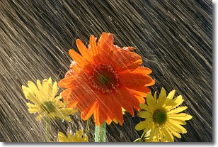
Weather Topic: What is Precipitation?
Home - Education - Precipitation - Precipitation
 Next Topic: Rain
Precipitation can refer to many different forms of water that
may fall from clouds. Precipitation occurs after a cloud has become saturated to
the point where its water particles are more dense than the air below the cloud.
In most cases, precipitation will reach the ground, but it is not uncommon for
precipitation to evaporate before it reaches the earth's surface.
When precipitation evaporates before it contacts the ground it is called Virga.
Graupel, hail, sleet, rain, drizzle, and snow are forms of precipitation, but fog
and mist are not considered precipitation because the water vapor which
constitutes them isn't dense enough to fall to the ground.
Next Topic: Rain
Current conditions powered by WeatherAPI.com


