Weather Alert in Oregon
Winter Weather Advisory issued February 18 at 10:00AM PST until February 20 at 4:00AM PST by NWS Portland OR
AREAS AFFECTED: North Oregon Coast Range Lowlands; North Oregon Coast Range; Central Oregon Coast Range; Clackamas County Cascade Foothills; Cascade Foothills of Marion and Linn Counties; Lane County Cascade Foothills; Willapa Hills; South Washington Cascade Foothills
DESCRIPTION: ...A SERIES OF WEAK SYSTEMS WILL BRING WIDESPREAD SNOW TO THE NORTHERN OREGON AND SOUTHERN WASHINGTON COAST AND CASCADE RANGES THROUGH AT LEAST THURSDAY NIGHT... .A broad area of low pressure will continue to bring widespread snow showers to elevations above 1000 ft through at least Thursday night. Given the showery nature of the precipitation and uncertainty as to the track of tonight's system, there is some variability in forecast total snow fall accumulations through Thursday night. While the forecast remains on track for overall snowfall totals, where exactly the highest snow accumulations occur remain in flux. * WHAT...Snow. Additional snow accumulations of 2 to 7 inches through tonight and another 1 to 3 inches of snow Thursday morning through Thursday night. * WHERE...Foothills of the Northern and Central Oregon Cascades, North and Central Coast Range Mountains of Oregon, North Oregon Coast Range Lowlands, Willapa Hills, and South Washington Cascade Foothills. * WHEN...Until 4 AM PST Friday. * IMPACTS...Roads, and especially bridges and overpasses, will likely become slick and hazardous.
INSTRUCTION: Have a winter emergency driving kit readily available. Common items to include: flashlight, batteries, blankets, a shovel, water, non-perishable food items, tire chains, etc. Be aware that walking surfaces may be slick. Walk with extra care. For the latest road conditions and chain restrictions in Oregon, call 5 1 1, or visit: www.tripcheck.com. For the latest road conditions and chain restrictions in Washington, visit: wsdot.com/travel/real-time/map
Want more detail? Get the Complete 7 Day and Night Detailed Forecast!
Current U.S. National Radar--Current
The Current National Weather Radar is shown below with a UTC Time (subtract 5 hours from UTC to get Eastern Time).

National Weather Forecast--Current
The Current National Weather Forecast and National Weather Map are shown below.

National Weather Forecast for Tomorrow
Tomorrow National Weather Forecast and Tomorrow National Weather Map are show below.

North America Water Vapor (Moisture)
This map shows recent moisture content over North America. Bright and colored areas show high moisture (ie, clouds); brown indicates very little moisture present; black indicates no moisture.

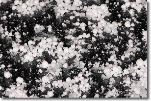
Weather Topic: What is Graupel?
Home - Education - Precipitation - Graupel
 Next Topic: Hail
Graupel is a form of precipitation that is created by atmospheric conditions
which cause supercooled water droplets to contact snow crystals and freeze to
their surface.
Sometimes known as soft hail or snow pellets, graupel is delicate and easily
destroyed by touch. Whereas hail usually falls during severe weather, graupel
doesn't require such conditions to form, and can form in mild precipitation
similar to situations which produce snowfall.
Next Topic: Hail
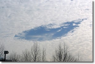
Weather Topic: What are Hole Punch Clouds?
Home - Education - Cloud Types - Hole Punch Clouds
 Next Topic: Mammatus Clouds
A hole punch cloud is an unusual occurrence when a disk-shaped
hole appears in a cirrostratus, cirrocumulus, or altocumulus cloud.
When part of the cloud forms ice crystals, water droplets in the surrounding area
of the cloud evaporate. The effect of this process produces a large elliptical
gap in the cloud. The hole punch cloud formation is rare, but it is not specific
to any geographic area.
Other names which have been used to describe this phenomena include fallstreak hole,
skypunch, and cloud hole.
Next Topic: Mammatus Clouds
Current conditions powered by WeatherAPI.com


