Weather Alert in Alaska
Special Weather Statement issued September 7 at 2:50PM AKDT by NWS Juneau AK
AREAS AFFECTED: City and Borough of Yakutat; Municipality of Skagway; Haines Borough and Klukwan; Glacier Bay; Eastern Chichagof Island; Cape Fairweather to Lisianski Strait; City and Borough of Sitka; Admiralty Island; City and Borough of Juneau; Petersburg Borough; Western Kupreanof and Kuiu Island; Prince of Wales Island; City and Borough of Wrangell; Ketchikan Gateway Borough; Annette Island
DESCRIPTION: A WET FALL STORM WILL BE IMPACTING THE PANHANDLE EARLY WEDNESDAY INTO THURSDAY NIGHT DROPPING AROUND 2 TO 4 INCHES OF RAIN FOR THE LOWER ELEVATIONS AND UP TO 6 INCHES FOR THE HIGHER ELEVATIONS OF THE PANHANDLE. FREEZING LEVELS ARE STILL HIGH AROUND 8000 TO 9000 FT ACROSS THE AREA SO MOST OF THE PRECIPITATION THAT FALLS AT ELEVATION WILL BE RAIN. AREA RIVERS AND STREAMS ARE EXPECTED TO EXPERIENCE RISES IN WATER LEVELS AND INCREASED FLOWS WEDNESDAY INTO THURSDAY IN RESPONSE TO THE HEAVIER RAINFALL, AND MAY STAY HIGH INTO FRIDAY. STAY TUNED FOR MORE UPDATES AS WE GET CLOSER TO THE EVENT.
INSTRUCTION: N/A
Want more detail? Get the Complete 7 Day and Night Detailed Forecast!
Current U.S. National Radar--Current
The Current National Weather Radar is shown below with a UTC Time (subtract 5 hours from UTC to get Eastern Time).

National Weather Forecast--Current
The Current National Weather Forecast and National Weather Map are shown below.

National Weather Forecast for Tomorrow
Tomorrow National Weather Forecast and Tomorrow National Weather Map are show below.

North America Water Vapor (Moisture)
This map shows recent moisture content over North America. Bright and colored areas show high moisture (ie, clouds); brown indicates very little moisture present; black indicates no moisture.

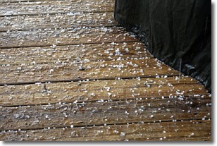
Weather Topic: What is Sleet?
Home - Education - Precipitation - Sleet
 Next Topic: Snow
Sleet is a form of precipitation in which small ice pellets are the primary
components. These ice pellets are smaller and more translucent than hailstones,
and harder than graupel. Sleet is caused by specific atmospheric conditions and
therefore typically doesn't last for extended periods of time.
The condition which leads to sleet formation requires a warmer body of air to be
wedged in between two sub-freezing bodies of air. When snow falls through a warmer
layer of air it melts, and as it falls through the next sub-freezing body of air
it freezes again, forming ice pellets known as sleet. In some cases, water
droplets don't have time to freeze before reaching the surface and the result is
freezing rain.
Next Topic: Snow
Weather Topic: What are Stratocumulus Clouds?
Home - Education - Cloud Types - Stratocumulus Clouds
 Next Topic: Stratus Clouds
Stratocumulus clouds are similar to altocumulus clouds in their
fluffy appearance, but have a slightly darker shade due to their additional mass.
A good way to distinguish the two cloud types is to hold your hand out and measure
the size of an individual cloud; if it is the size of your thumb it is generally
an altocumulus cloud, if it is the size of your hand it is generally a
stratocumulus cloud.
It is uncommon for stratocumulus clouds to produce precipitation, but if they do
it is usually a light rain or snow.
Next Topic: Stratus Clouds
Current conditions powered by WeatherAPI.com


