Weather Alert in Minnesota
Winter Weather Advisory issued February 27 at 11:59AM CST until February 28 at 6:00PM CST by NWS La Crosse WI
AREAS AFFECTED: Wabasha; Winona; Buffalo; Trempealeau; Jackson; La Crosse; Monroe; Juneau; Adams
DESCRIPTION: ...BAND OF SNOW MOVES IN SATURDAY MORNING... .A narrow band of snow will move in from the west on Saturday morning and continue throughout much of the daytime hours. Snowfall rates of an inch an hour will be possible within the band resulting in quick accumulations on roadways. Snowfall amounts within the band will likely range between 2 to 4 inches with locally higher amounts of up to 6 inches possible. The exact location of the heaviest amounts still remains uncertain with a sharp cutoff in amounts possible over just a few miles. As a result, be sure to continue to monitor the forecast for updates as the location of snowfall amounts may still shift. * WHAT...Snow expected. Total snow accumulations between 1 and 4 inches. Locally higher amounts will be possible. * WHERE...Portions of southeast Minnesota and central and west central Wisconsin. * WHEN...From 6 AM to 6 PM CST Saturday. * IMPACTS...Plan on slippery road conditions.
INSTRUCTION: Slow down and use caution while traveling. In Minnesota, visit 511mn.org for road conditions. In Wisconsin, visit 511wi.gov for road conditions.
Want more detail? Get the Complete 7 Day and Night Detailed Forecast!
Current U.S. National Radar--Current
The Current National Weather Radar is shown below with a UTC Time (subtract 5 hours from UTC to get Eastern Time).

National Weather Forecast--Current
The Current National Weather Forecast and National Weather Map are shown below.

National Weather Forecast for Tomorrow
Tomorrow National Weather Forecast and Tomorrow National Weather Map are show below.

North America Water Vapor (Moisture)
This map shows recent moisture content over North America. Bright and colored areas show high moisture (ie, clouds); brown indicates very little moisture present; black indicates no moisture.

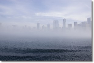
Weather Topic: What is Fog?
Home - Education - Cloud Types - Fog
 Next Topic: Fractus Clouds
Fog is technically a type of stratus cloud, which lies along the
ground and obscures visibility.
It is usually created when humidity in the air condenses into tiny water droplets.
Because of this, some places are more prone to foggy weather, such as regions
close to a body of water.
Fog is similar to mist; both are the appearance of water droplets suspended in
the air, but fog is the term applied to the condition when visibility is less than 1 km.
Next Topic: Fractus Clouds
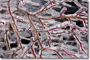
Weather Topic: What is Freezing Rain?
Home - Education - Precipitation - Freezing Rain
 Next Topic: Graupel
Freezing rain is a condition where precipitation which has fallen in the form of
water droplets reaches temperatures which are below freezing and freezes upon
coming into contact
with surface objects. The result of this precipitation is a glaze of ice which
can be damaging to plants and man-made structures. A severe onset of freezing
rain which results in a very thick glaze of ice is known as an ice storm.
Next Topic: Graupel
Current conditions powered by WeatherAPI.com


