Weather Alert in Utah
High Wind Warning issued February 16 at 5:47PM MST until February 17 at 5:00AM MST by NWS Salt Lake City UT
AREAS AFFECTED: Great Salt Lake Desert and Mountains; Tooele and Rush Valleys
DESCRIPTION: * WHAT...South winds 30 to 40 mph with gusts up to 60 mph, with localized downslope winds over 70 mph possible along portions of I-80 north of the Oquirrh, Stansbury, and Cedar Mountains. * WHERE...Great Salt Lake Desert and Mountains and Tooele and Rush Valleys. * WHEN...Until 5 AM MST Tuesday. * IMPACTS...High winds may move loose debris, damage property and cause power outages. Travel could be difficult, especially for high profile vehicles and vehicles with trailers. * ADDITIONAL DETAILS...Areas of blowing dust will reduce visibility below 2 miles at times on I-80, particularly between Wendover and Grantsville.
INSTRUCTION: Winds this strong can make driving difficult, especially for high profile vehicles and vehicles with trailers. Use extra caution. Blowing dust will reduce visibility at times. Slow down and use extra caution in areas of blowing dust. People are urged to secure loose objects that could be blown around or damaged by the wind.
Want more detail? Get the Complete 7 Day and Night Detailed Forecast!
Current U.S. National Radar--Current
The Current National Weather Radar is shown below with a UTC Time (subtract 5 hours from UTC to get Eastern Time).

National Weather Forecast--Current
The Current National Weather Forecast and National Weather Map are shown below.

National Weather Forecast for Tomorrow
Tomorrow National Weather Forecast and Tomorrow National Weather Map are show below.

North America Water Vapor (Moisture)
This map shows recent moisture content over North America. Bright and colored areas show high moisture (ie, clouds); brown indicates very little moisture present; black indicates no moisture.

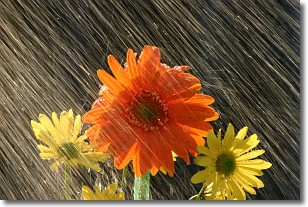
Weather Topic: What is Rain?
Home - Education - Precipitation - Rain
 Next Topic: Shelf Clouds
Precipitation in the form of water droplets is called rain.
Rain generally has a tendency to fall with less intensity over a greater period
of time, and when rainfall is more severe it is usually less sustained.
Rain is the most common form of precipitation and happens with greater frequency
depending on the season and regional influences. Cities have been shown to have
an observable effect on rainfall, due to an effect called the urban heat island.
Compared to upwind, monthly rainfall between twenty and forty miles downwind of
cities is 30% greater.
Next Topic: Shelf Clouds
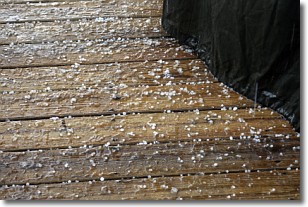
Weather Topic: What is Sleet?
Home - Education - Precipitation - Sleet
 Next Topic: Snow
Sleet is a form of precipitation in which small ice pellets are the primary
components. These ice pellets are smaller and more translucent than hailstones,
and harder than graupel. Sleet is caused by specific atmospheric conditions and
therefore typically doesn't last for extended periods of time.
The condition which leads to sleet formation requires a warmer body of air to be
wedged in between two sub-freezing bodies of air. When snow falls through a warmer
layer of air it melts, and as it falls through the next sub-freezing body of air
it freezes again, forming ice pellets known as sleet. In some cases, water
droplets don't have time to freeze before reaching the surface and the result is
freezing rain.
Next Topic: Snow
Current conditions powered by WeatherAPI.com


