Weather Alert in Alaska
Flood Watch issued September 1 at 9:44AM AKDT until September 3 at 12:00PM AKDT by NWS Fairbanks AK
AREAS AFFECTED: South Slopes of the Western Brooks Range; Noatak Valley; Upper Kobuk Valleys; Lower Koyukuk Valley; Upper Koyukuk Valley
DESCRIPTION: * WHAT...Flooding caused by excessive rainfall continues to be possible. * WHERE...Including the Noatak, Kobuk, and Koyukuk Rivers. * WHEN...Through Wednesday morning. * IMPACTS...Excessive runoff from last week's rainfall is resulting in flooding of rivers, creeks, streams, and other low-lying and flood-prone locations. * ADDITIONAL DETAILS... - Flooding of roadways has been reported in Kobuk and Allakaket. River levels are also at flood stage in Hughes. An additional 0.50 to 1.00 inch of rainfall is expected in the Southern Brooks Range through Tuesday, which is forecast to prolong high water levels this week. Another rainmaker will arrive Wednesday evening. This may bring another 0.50 to 1.00 inch to the Southern Brooks Range. - Http://www.weather.gov/aprfc
INSTRUCTION: Persons living along streams should stay alert and be prepared to take action if a warning or advisory is issued, or flooding is observed. You should monitor later forecasts and be alert for possible Flood Warnings. Those living in areas prone to flooding should be prepared to take action should flooding develop. Stay tuned to further developments by listening to your local radio, television, or NOAA Weather Radio for further information.
Want more detail? Get the Complete 7 Day and Night Detailed Forecast!
Current U.S. National Radar--Current
The Current National Weather Radar is shown below with a UTC Time (subtract 5 hours from UTC to get Eastern Time).

National Weather Forecast--Current
The Current National Weather Forecast and National Weather Map are shown below.

National Weather Forecast for Tomorrow
Tomorrow National Weather Forecast and Tomorrow National Weather Map are show below.

North America Water Vapor (Moisture)
This map shows recent moisture content over North America. Bright and colored areas show high moisture (ie, clouds); brown indicates very little moisture present; black indicates no moisture.

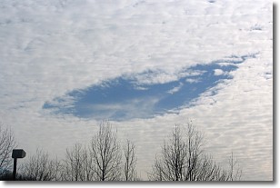
Weather Topic: What are Hole Punch Clouds?
Home - Education - Cloud Types - Hole Punch Clouds
 Next Topic: Mammatus Clouds
A hole punch cloud is an unusual occurrence when a disk-shaped
hole appears in a cirrostratus, cirrocumulus, or altocumulus cloud.
When part of the cloud forms ice crystals, water droplets in the surrounding area
of the cloud evaporate. The effect of this process produces a large elliptical
gap in the cloud. The hole punch cloud formation is rare, but it is not specific
to any geographic area.
Other names which have been used to describe this phenomena include fallstreak hole,
skypunch, and cloud hole.
Next Topic: Mammatus Clouds
Weather Topic: What are Nimbostratus Clouds?
Home - Education - Cloud Types - Nimbostratus Clouds
 Next Topic: Precipitation
A nimbostratus cloud is similar to a stratus cloud in its formless,
smooth appearance. However, a nimbostratus cloud is darker than a stratus cloud,
because it is thicker.
Unlike a stratus cloud, a nimbostratus cloud typically brings with it the threat
of moderate to heavy precipitation. In some cases, the precipitation may evaporate
before reaching the ground, a phenomenon known as virga.
Next Topic: Precipitation
Current conditions powered by WeatherAPI.com


