Weather Alert in California
Special Weather Statement issued February 16 at 11:53AM PST by NWS Los Angeles/Oxnard CA
AREAS AFFECTED: San Luis Obispo County Inland Central Coast; Santa Lucia Mountains; Southern Salinas Valley; San Luis Obispo County Interior Valleys; San Luis Obispo County Mountains; Santa Barbara County Inland Central Coast; Santa Ynez Valley; Santa Barbara County Southwestern Coast; Santa Ynez Mountains Western Range; Santa Barbara County Interior Mountains
DESCRIPTION: At 1152 AM PST, Doppler radar was tracking strong thunderstorms along a line extending from 9 miles northwest of Atascadero to 9 miles northwest of Highway 101 through Gaviota State Park. Movement was northeast at 25 mph. HAZARD...Wind gusts up to 50 mph. SOURCE...Radar indicated. IMPACT...Gusty winds could knock down tree limbs and blow around unsecured objects. A weak brief tornado is possible. Locations impacted include... Santa Maria... San Luis Obispo... Paso Robles... Santa Ynez... Atascadero... Arroyo Grande... Nipomo... Solvang... Los Alamos... Refugio State Beach... El Capitan State Beach... Orcutt... Highway 101 through Gaviota State Park... Buellton... Sisquoc... Santa Margarita... Templeton... Highway 101 over Cuesta Grade... and Lake Lopez.
INSTRUCTION: If outdoors, consider seeking shelter inside a building.
Want more detail? Get the Complete 7 Day and Night Detailed Forecast!
Current U.S. National Radar--Current
The Current National Weather Radar is shown below with a UTC Time (subtract 5 hours from UTC to get Eastern Time).

National Weather Forecast--Current
The Current National Weather Forecast and National Weather Map are shown below.

National Weather Forecast for Tomorrow
Tomorrow National Weather Forecast and Tomorrow National Weather Map are show below.

North America Water Vapor (Moisture)
This map shows recent moisture content over North America. Bright and colored areas show high moisture (ie, clouds); brown indicates very little moisture present; black indicates no moisture.

Weather Topic: What are Stratus Clouds?
Home - Education - Cloud Types - Stratus Clouds
 Next Topic: Wall Clouds
Stratus clouds are similar to altostratus clouds, but form at a
lower altitude and are identified by their fog-like appearance, lacking the
distinguishing features of most clouds.
Stratus clouds are wider than most clouds, and their base has a smooth, uniform
look which is lighter in color than a nimbostratus cloud.
The presence of a stratus cloud indicates the possibility of minor precipitation,
such as drizzle, but heavier precipitation does not typically arrive in the form
of a stratus cloud.
Next Topic: Wall Clouds
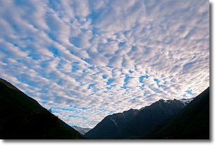
Weather Topic: What are Altocumulus Clouds?
Home - Education - Cloud Types - Altocumulus Clouds
 Next Topic: Altostratus Clouds
Similar to cirrocumulus clouds, altocumulus clouds are
characterized by cloud patches. They are distinguished by larger cloudlets
than cirrocumulus clouds but are still smaller than stratocumulus clouds.
Altocumulus clouds most commonly form in middle altitudes (between 2 and 5 km)
and may resemble, at times, the shape of a flying saucer.
These uncommon formations, called altocumulus lenticularis, are created by uplift
in the atmosphere and are most often seen in close proximity to mountains.
Next Topic: Altostratus Clouds
Current conditions powered by WeatherAPI.com


