Weather Alert in Texas
Special Weather Statement issued August 3 at 1:01PM CDT by NWS Fort Worth TX
AREAS AFFECTED: Denton; Collin; Tarrant; Dallas; Johnson; Ellis
DESCRIPTION: At 100 PM CDT, Doppler radar was tracking strong thunderstorms along a line extending from near Prosper to near Godley. Movement was southeast at 20 mph. HAZARD...Wind gusts up to 50 mph and pea size hail. SOURCE...Radar indicated. IMPACT...Gusty winds could knock down tree limbs and blow around unsecured objects. Minor damage to outdoor objects is possible. Strong thunderstorms will be near... Dallas, Fort Worth, Arlington, Irving, Carrollton, Frisco, Lewisville, Flower Mound, Euless, and Bedford around 105 PM CDT. Plano, Grand Prairie, McKinney, Mansfield, and Keene around 110 PM CDT. Farmers Branch around 115 PM CDT. Allen and Addison around 120 PM CDT. Alvarado around 125 PM CDT. Other locations impacted by these storms include Lake Arlington, Rio Vista, Parker, Joe Pool Lake, Mountain Creek Lake, Sand Flat, Egan, Lillian, Lewisville Lake, and New Hope. This includes the following highways... Interstate 35W between mile markers 17 and 49. Interstate 35E between mile markers 428 and 456. Interstate 20 between mile markers 435 and 461. Interstate 30 between mile markers 17 and 44.
INSTRUCTION: If outdoors, consider seeking shelter inside a building. Torrential rainfall is also occurring with these storms and may lead to localized flooding. Do not drive your vehicle through flooded roadways. Frequent cloud to ground lightning is occurring with these storms. Lightning can strike 10 miles away from a thunderstorm. Seek a safe shelter inside a building or vehicle.
Want more detail? Get the Complete 7 Day and Night Detailed Forecast!
Current U.S. National Radar--Current
The Current National Weather Radar is shown below with a UTC Time (subtract 5 hours from UTC to get Eastern Time).

National Weather Forecast--Current
The Current National Weather Forecast and National Weather Map are shown below.

National Weather Forecast for Tomorrow
Tomorrow National Weather Forecast and Tomorrow National Weather Map are show below.

North America Water Vapor (Moisture)
This map shows recent moisture content over North America. Bright and colored areas show high moisture (ie, clouds); brown indicates very little moisture present; black indicates no moisture.

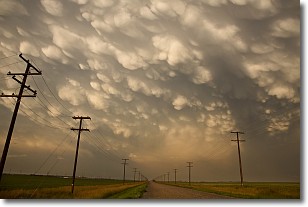
Weather Topic: What are Mammatus Clouds?
Home - Education - Cloud Types - Mammatus Clouds
 Next Topic: Nimbostratus Clouds
A mammatus cloud is a cloud with a unique feature which resembles
a web of pouches hanging along the base of the cloud.
In the United States, mammatus clouds tend to form in the warmer months, commonly
in the Midwest and eastern regions.
While they usually form at the bottom of a cumulonimbis cloud, they can also form
under altostratus, altocumulus, stratocumulus, and cirrus clouds. Mammatus clouds
warn that severe weather is close.
Next Topic: Nimbostratus Clouds
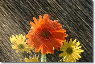
Weather Topic: What is Precipitation?
Home - Education - Precipitation - Precipitation
 Next Topic: Rain
Precipitation can refer to many different forms of water that
may fall from clouds. Precipitation occurs after a cloud has become saturated to
the point where its water particles are more dense than the air below the cloud.
In most cases, precipitation will reach the ground, but it is not uncommon for
precipitation to evaporate before it reaches the earth's surface.
When precipitation evaporates before it contacts the ground it is called Virga.
Graupel, hail, sleet, rain, drizzle, and snow are forms of precipitation, but fog
and mist are not considered precipitation because the water vapor which
constitutes them isn't dense enough to fall to the ground.
Next Topic: Rain
Current conditions powered by WeatherAPI.com


