Weather Alert in California
Special Weather Statement issued July 30 at 2:39PM PDT by NWS Los Angeles/Oxnard CA
AREAS AFFECTED: Catalina and Santa Barbara Islands; San Luis Obispo County Beaches; Santa Barbara County Central Coast Beaches; Santa Barbara County Southwestern Coast; Santa Barbara County Southeastern Coast; Ventura County Beaches; Malibu Coast; Los Angeles County Beaches
DESCRIPTION: ...ALL TSUNAMI ADVISORIES HAVE BEEN CANCELLED... * UPDATES... All Tsunami Advisories have been cancelled. However, tidal fluctuations and enhanced currents will continue for the next few days. * LOCAL IMPACTS... While the tsunami is expected to remain below advisory criteria, strong currents will pose a risk for ocean swimmers. * RECOMMENDED ACTIONS... If you are located in this coastal area, check in with local lifeguards before entering the water. Be alert to instructions from your local emergency officials. * OBSERVED TSUNAMI WAVE HEIGHTS FROM EARLIER... Port San Luis California 2.7 ft at 0214 AM PDT on Jul 30 Santa Barbara California 1.5 ft at 0706 AM PDT on Jul 30 Santa Monica California 1.2 ft at 0827 AM PDT on Jul 30 Los Angeles Harbor CA 0.5 ft at 0546 AM PDT on Jul 30 This will be the final statement issued for the local area for this event.
INSTRUCTION: N/A
Want more detail? Get the Complete 7 Day and Night Detailed Forecast!
Current U.S. National Radar--Current
The Current National Weather Radar is shown below with a UTC Time (subtract 5 hours from UTC to get Eastern Time).

National Weather Forecast--Current
The Current National Weather Forecast and National Weather Map are shown below.

National Weather Forecast for Tomorrow
Tomorrow National Weather Forecast and Tomorrow National Weather Map are show below.

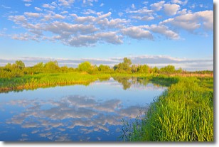
North America Water Vapor (Moisture)
This map shows recent moisture content over North America. Bright and colored areas show high moisture (ie, clouds); brown indicates very little moisture present; black indicates no moisture.

Weather Topic: What are Stratocumulus Clouds?
Home - Education - Cloud Types - Stratocumulus Clouds
 Next Topic: Stratus Clouds
Stratocumulus clouds are similar to altocumulus clouds in their
fluffy appearance, but have a slightly darker shade due to their additional mass.
A good way to distinguish the two cloud types is to hold your hand out and measure
the size of an individual cloud; if it is the size of your thumb it is generally
an altocumulus cloud, if it is the size of your hand it is generally a
stratocumulus cloud.
It is uncommon for stratocumulus clouds to produce precipitation, but if they do
it is usually a light rain or snow.
Next Topic: Stratus Clouds
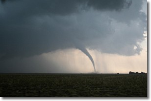
Weather Topic: What are Wall Clouds?
Home - Education - Cloud Types - Wall Clouds
 Next Topic: Altocumulus Clouds
A wall cloud forms underneath the base of a cumulonimbus cloud,
and can be a hotbed for deadly tornadoes.
Wall clouds are formed by air flowing into the cumulonimbus clouds, which can
result in the wall cloud descending from the base of the cumulonimbus cloud, or
rising fractus clouds which join to the base of the storm cloud as the wall cloud
takes shape.
Wall clouds can be very large, and in the Northern Hemisphere they generally
form at the southern edge of cumulonimbus clouds.
Next Topic: Altocumulus Clouds
Current conditions powered by WeatherAPI.com


