Weather Alert in Arizona
Dust Storm Warning issued August 25 at 3:36PM MST until August 25 at 5:00PM MST by NWS Tucson AZ
AREAS AFFECTED: Pima, AZ; Pinal, AZ
DESCRIPTION: The National Weather Service in Tucson has issued a * Dust Storm Warning for... North Central Pima County in southeastern Arizona... Southwestern Pinal County in southeastern Arizona... * Until 500 PM MST. * At 336 PM MST, an area of blowing dust was located 12 miles north of Santa Rosa, moving north at 20 mph. HAZARD...Less than a quarter mile visibility with strong winds in excess of 50 mph. SOURCE...Public reported. IMPACT...Dangerous life-threatening travel. * Locations impacted include... Oro Valley, Marana, Casas Adobes, Eloy, Avra Valley, Tortolita, Picacho, Chui-Chu, Picacho Peak State Park, Pinal Airpark, Picture Rocks, Red Rock, Cockleburr, North Komelik, Kohatk, Jack Rabbit, Shopishk, East Chui-Chu, Silver Bell and Dove Mountain. This includes the following highways... Route 87 between mile markers 116 and 123. Interstate 10 between mile markers 206 and 245.
INSTRUCTION: Motorists should not drive into a dust storm. PULL ASIDE STAY ALIVE! Dust storms lead to dangerous driving conditions with visibility reduced to near zero. If driving, avoid dust storms if possible. If caught in one, pull off the road, turn off your lights and keep your foot off the brake.
Want more detail? Get the Complete 7 Day and Night Detailed Forecast!
Current U.S. National Radar--Current
The Current National Weather Radar is shown below with a UTC Time (subtract 5 hours from UTC to get Eastern Time).

National Weather Forecast--Current
The Current National Weather Forecast and National Weather Map are shown below.

National Weather Forecast for Tomorrow
Tomorrow National Weather Forecast and Tomorrow National Weather Map are show below.

North America Water Vapor (Moisture)
This map shows recent moisture content over North America. Bright and colored areas show high moisture (ie, clouds); brown indicates very little moisture present; black indicates no moisture.

Weather Topic: What are Fractus Clouds?
Home - Education - Cloud Types - Fractus Clouds
 Next Topic: Freezing Rain
A fractus cloud (scud) is a fragmented, tattered cloud which has
likely been sheared off of another cloud. They are accessory clouds, meaning they
develop from parent clouds, and are named in a way which describes the original
cloud which contained them.
Fractus clouds which have originated from cumulus clouds are referred to as
cumulus fractus, while fractus clouds which have originated from stratus clouds
are referred to as stratus fractus. Under certain conditions a fractus cloud might
merge with another cloud, or develop into a cumulus cloud, but usually a
fractus cloud seen by itself will dissipate rapidly.
They are often observed on the leading and trailing edges of storm clouds,
and are a display of wind activity.
Next Topic: Freezing Rain
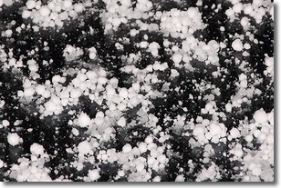
Weather Topic: What is Graupel?
Home - Education - Precipitation - Graupel
 Next Topic: Hail
Graupel is a form of precipitation that is created by atmospheric conditions
which cause supercooled water droplets to contact snow crystals and freeze to
their surface.
Sometimes known as soft hail or snow pellets, graupel is delicate and easily
destroyed by touch. Whereas hail usually falls during severe weather, graupel
doesn't require such conditions to form, and can form in mild precipitation
similar to situations which produce snowfall.
Next Topic: Hail
Current conditions powered by WeatherAPI.com


