Weather Alert in New Mexico
High Wind Watch issued February 18 at 8:51PM MST until February 20 at 8:00PM MST by NWS Midland/Odessa TX
AREAS AFFECTED: Guadalupe Mountains of Eddy County; Guadalupe Mountains Above 7000 Feet; Guadalupe and Delaware Mountains
DESCRIPTION: * WHAT...For the High Wind Warning, west winds 35 to 55 mph with gusts up to 75 mph. For the High Wind Watch, west winds 30 to 50 mph with gusts up to 70 mph possible. * WHERE...Guadalupe Mountains of west Texas and Southeast New Mexico. * WHEN...For the High Wind Warning, until 9 PM MST /10 PM CST/ Thursday. For the High Wind Watch, from Friday morning through Friday evening. * IMPACTS...Travel will be difficult, especially for high profile vehicles like campers, vans, and tractor trailers. Severe turbulence near the mountains will be hazardous for low flying light aircraft. Aviation interests may experience localized but extreme turbulence, or strong downward airflows if flying in the near the Guadalupe Mountains.
INSTRUCTION: Winds will be particularly hazardous at higher elevations where the strongest winds are likely to occur. Be especially careful driving in these mountainous areas. People driving high-profile vehicles should strongly consider postponing travel in these areas until the winds subside. Use caution when driving as blowing dust may reduce visibility. Monitor the latest forecasts and warnings for updates. Use caution if flying low near the mountains as severe turbulence is possible.
Want more detail? Get the Complete 7 Day and Night Detailed Forecast!
Current U.S. National Radar--Current
The Current National Weather Radar is shown below with a UTC Time (subtract 5 hours from UTC to get Eastern Time).

National Weather Forecast--Current
The Current National Weather Forecast and National Weather Map are shown below.

National Weather Forecast for Tomorrow
Tomorrow National Weather Forecast and Tomorrow National Weather Map are show below.

North America Water Vapor (Moisture)
This map shows recent moisture content over North America. Bright and colored areas show high moisture (ie, clouds); brown indicates very little moisture present; black indicates no moisture.

Weather Topic: What is Drizzle?
Home - Education - Precipitation - Drizzle
 Next Topic: Evaporation
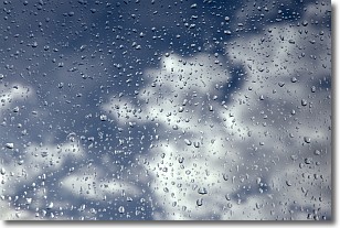
Drizzle is precipitation in the form of water droplets which are
smaller than raindrops.
Drizzle is characterized by fine, gently falling droplets and typically does not
impact human habitation in a negative way. The exception to this is freezing drizzle,
a condition where drizzle freezes immediately upon reaching earth's surface.
Freezing drizzle is still less dangerous than freezing rain, but can
potentially result in hazardous road conditions.
Next Topic: Evaporation
Weather Topic: What is Fog?
Home - Education - Cloud Types - Fog
 Next Topic: Fractus Clouds
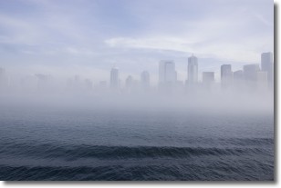
Fog is technically a type of stratus cloud, which lies along the
ground and obscures visibility.
It is usually created when humidity in the air condenses into tiny water droplets.
Because of this, some places are more prone to foggy weather, such as regions
close to a body of water.
Fog is similar to mist; both are the appearance of water droplets suspended in
the air, but fog is the term applied to the condition when visibility is less than 1 km.
Next Topic: Fractus Clouds
Current conditions powered by WeatherAPI.com


