Weather Alert in California
Winter Storm Watch issued February 15 at 5:00AM PST until February 19 at 9:00AM PST by NWS San Diego CA
AREAS AFFECTED: Riverside County Mountains
DESCRIPTION: * WHAT...Heavy snow possible. For first round Monday, 3-6 inches expected between 6000-7000 ft, 6-12 inches expected above 7000 ft. West winds gusting to 55 mph on the ridges and desert slopes. Occasional light snow during the day Tuesday, with the next round of moderate snow and gusty winds Wednesday into Thursday morning. Wind gusts as high as 70 mph possible on the desert slopes of the mountains late Tuesday and Wednesday. * WHERE...Riverside County Mountains. * WHEN...From Monday morning through Thursday morning. * IMPACTS...Roads, and especially bridges and overpasses, will likely become slick and hazardous. Visibilities may drop below 1/4 mile due to falling and blowing snow. Travel could be very difficult to impossible. The hazardous conditions could impact the Monday evening and Tuesday morning commutes. Very strong winds could cause extensive tree damage. * ADDITIONAL DETAILS...For the first round Monday, snow levels will start around 7000 ft and fall to near 5000 ft. Lower snow levels near 4,000 feet possible Wednesday morning and Thursday.
INSTRUCTION: Monitor the latest forecasts for updates on this situation.
Want more detail? Get the Complete 7 Day and Night Detailed Forecast!
Current U.S. National Radar--Current
The Current National Weather Radar is shown below with a UTC Time (subtract 5 hours from UTC to get Eastern Time).

National Weather Forecast--Current
The Current National Weather Forecast and National Weather Map are shown below.

National Weather Forecast for Tomorrow
Tomorrow National Weather Forecast and Tomorrow National Weather Map are show below.

North America Water Vapor (Moisture)
This map shows recent moisture content over North America. Bright and colored areas show high moisture (ie, clouds); brown indicates very little moisture present; black indicates no moisture.

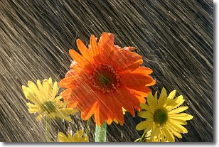
Weather Topic: What is Precipitation?
Home - Education - Precipitation - Precipitation
 Next Topic: Rain
Precipitation can refer to many different forms of water that
may fall from clouds. Precipitation occurs after a cloud has become saturated to
the point where its water particles are more dense than the air below the cloud.
In most cases, precipitation will reach the ground, but it is not uncommon for
precipitation to evaporate before it reaches the earth's surface.
When precipitation evaporates before it contacts the ground it is called Virga.
Graupel, hail, sleet, rain, drizzle, and snow are forms of precipitation, but fog
and mist are not considered precipitation because the water vapor which
constitutes them isn't dense enough to fall to the ground.
Next Topic: Rain
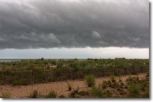
Weather Topic: What are Shelf Clouds?
Home - Education - Cloud Types - Shelf Clouds
 Next Topic: Sleet
A shelf cloud is similar to a wall cloud, but forms at the front
of a storm cloud, instead of at the rear, where wall clouds form.
A shelf cloud is caused by a series of events set into motion by the advancing
storm; first, cool air settles along the ground where precipitation has just fallen.
As the cool air is brought in, the warmer air is displaced, and rises above it,
because it is less dense. When the warmer air reaches the bottom of the storm cloud,
it begins to cool again, and the resulting condensation is a visible shelf cloud.
Next Topic: Sleet
Current conditions powered by WeatherAPI.com


