Weather Alert in Colorado
Winter Storm Warning issued February 16 at 2:02AM MST until February 18 at 11:00PM MST by NWS Pueblo CO
AREAS AFFECTED: Eastern Sawatch Mountains above 11000 Ft; Eastern San Juan Mountains Above 10000 Ft
DESCRIPTION: * WHAT...Heavy wind driven snow expected. Total snow accumulations between 8 and 14 inches. Up to 24 inches possible across portions of the Eastern San Juan Mountains. Winds gusting as high as 70 mph causing blowing and drifting snow. * WHERE...Eastern Sawatch Mountains Above 11000 Feet and Eastern San Juan Mountains Above 10000 Feet. * WHEN...From 11 PM this evening to 11 PM MST Wednesday. * IMPACTS...Travel could be very difficult to impossible. Widespread blowing snow could significantly reduce visibility. Very strong winds could cause power outages and tree damage.
INSTRUCTION: If you must travel, keep an extra flashlight, food, and water in your vehicle in case of an emergency. The latest road conditions for the state you are calling from can be obtained by calling 5 1 1.
Want more detail? Get the Complete 7 Day and Night Detailed Forecast!
Current U.S. National Radar--Current
The Current National Weather Radar is shown below with a UTC Time (subtract 5 hours from UTC to get Eastern Time).

National Weather Forecast--Current
The Current National Weather Forecast and National Weather Map are shown below.

National Weather Forecast for Tomorrow
Tomorrow National Weather Forecast and Tomorrow National Weather Map are show below.

North America Water Vapor (Moisture)
This map shows recent moisture content over North America. Bright and colored areas show high moisture (ie, clouds); brown indicates very little moisture present; black indicates no moisture.

Weather Topic: What is Hail?
Home - Education - Precipitation - Hail
 Next Topic: Hole Punch Clouds
Hail is a form of precipitation which is recognized by large solid balls or
clumps of ice. Hail is created by thunderstorm clouds with strong updrafts of wind.
As the hailstones remain in the updraft, ice is deposited onto them until their
weight becomes heavy enough for them to fall to the earth's surface.
Hail storms can cause significant damage to crops, aircrafts, and man-made structures,
despite the fact that the duration is usually less than ten minutes.
Next Topic: Hole Punch Clouds
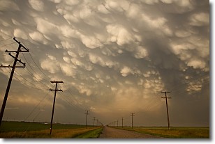
Weather Topic: What are Mammatus Clouds?
Home - Education - Cloud Types - Mammatus Clouds
 Next Topic: Nimbostratus Clouds
A mammatus cloud is a cloud with a unique feature which resembles
a web of pouches hanging along the base of the cloud.
In the United States, mammatus clouds tend to form in the warmer months, commonly
in the Midwest and eastern regions.
While they usually form at the bottom of a cumulonimbis cloud, they can also form
under altostratus, altocumulus, stratocumulus, and cirrus clouds. Mammatus clouds
warn that severe weather is close.
Next Topic: Nimbostratus Clouds
Current conditions powered by WeatherAPI.com


