Weather Alert in Missouri
Flood Warning issued April 2 at 8:20AM CDT until April 4 at 3:50PM CDT by NWS Kansas City/Pleasant Hill MO
AREAS AFFECTED: Cooper, MO
DESCRIPTION: ...The Flood Warning is extended for the following rivers in Missouri... Big Creek at Blairstown affecting Johnson, Henry and Cass Counties. Blackwater River at Valley City affecting Johnson and Pettis Counties. Lamine River near Otterville affecting Cooper County. Petite Saline Creek near Boonville affecting Cooper County. South Grand River at Urich affecting Henry, Bates and Cass Counties. Wakenda Creek at Carrollton affecting Carroll County. * WHAT...Minor flooding is occurring and moderate flooding is forecast. * WHERE...Lamine River near Otterville. * WHEN...From this morning to Saturday afternoon. * IMPACTS...At 15.0 feet, Low lying woodlands and fields along the river flood. At 18.0 feet, Some gravel roads upstream and downstream from Otterville are under water. In addition State Highway 135 may be overtopped by flood waters 2 miles north of Clifton City. * ADDITIONAL DETAILS... - At 7:15 AM CDT Thursday the stage was 15.4 feet. - Forecast...The river is expected to rise to a crest of 21.3 feet this evening. It will then fall below flood stage tomorrow afternoon. - Flood stage is 15.0 feet. - http://www.weather.gov/safety/flood
INSTRUCTION: Turn around, don't drown when encountering flooded roads. Most flood deaths occur in vehicles. This product along with additional weather and stream information is available at www.weather.gov/kc/.
Want more detail? Get the Complete 7 Day and Night Detailed Forecast!
Current U.S. National Radar--Current
The Current National Weather Radar is shown below with a UTC Time (subtract 5 hours from UTC to get Eastern Time).

National Weather Forecast--Current
The Current National Weather Forecast and National Weather Map are shown below.

National Weather Forecast for Tomorrow
Tomorrow National Weather Forecast and Tomorrow National Weather Map are show below.

North America Water Vapor (Moisture)
This map shows recent moisture content over North America. Bright and colored areas show high moisture (ie, clouds); brown indicates very little moisture present; black indicates no moisture.

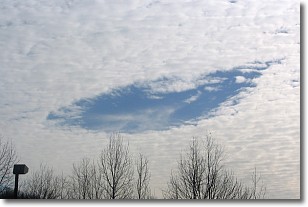
Weather Topic: What are Hole Punch Clouds?
Home - Education - Cloud Types - Hole Punch Clouds
 Next Topic: Mammatus Clouds
A hole punch cloud is an unusual occurrence when a disk-shaped
hole appears in a cirrostratus, cirrocumulus, or altocumulus cloud.
When part of the cloud forms ice crystals, water droplets in the surrounding area
of the cloud evaporate. The effect of this process produces a large elliptical
gap in the cloud. The hole punch cloud formation is rare, but it is not specific
to any geographic area.
Other names which have been used to describe this phenomena include fallstreak hole,
skypunch, and cloud hole.
Next Topic: Mammatus Clouds
Weather Topic: What are Nimbostratus Clouds?
Home - Education - Cloud Types - Nimbostratus Clouds
 Next Topic: Precipitation
A nimbostratus cloud is similar to a stratus cloud in its formless,
smooth appearance. However, a nimbostratus cloud is darker than a stratus cloud,
because it is thicker.
Unlike a stratus cloud, a nimbostratus cloud typically brings with it the threat
of moderate to heavy precipitation. In some cases, the precipitation may evaporate
before reaching the ground, a phenomenon known as virga.
Next Topic: Precipitation
Current conditions powered by WeatherAPI.com


