Weather Alert in Michigan
Winter Storm Watch issued April 2 at 1:04AM EDT until April 4 at 11:00AM EDT by NWS Marquette MI
AREAS AFFECTED: Keweenaw; Ontonagon; Houghton; Southern Houghton
DESCRIPTION: * WHAT...For the Winter Storm Warning, heavy mixed precipitation expected. Total snow and sleet accumulations between 2 and 6 inches and ice accumulations around two tenths of an inch in the areas south of Houghton along and south of M-26. Winds gusting as high as 40 mph. For the Winter Storm Watch, heavy mixed precipitation possible. Total snow and sleet accumulations up to two inches and ice accumulations between one tenth and four tenths of an inch possible. Winds could gust as high as 35 mph. * WHERE...Keweenaw, Northern Houghton, Ontonagon, and Southern Houghton Counties. * WHEN...For the Winter Storm Warning, from 10 AM this morning to 8 AM EDT Friday. For the Winter Storm Watch, from Friday evening through Saturday morning. * IMPACTS...Power outages and tree damage are likely due to the ice and wind. Travel could be very difficult to nearly impossible. The hazardous conditions will impact the Thursday evening and Friday morning commutes. * ADDITIONAL DETAILS...Accumulating sleet will be difficult to remove.
INSTRUCTION: Monitor the latest forecasts for updates on this situation. If you must travel, keep an extra flashlight, food, and water in your vehicle in case of an emergency. Prepare for possible power outages.
Want more detail? Get the Complete 7 Day and Night Detailed Forecast!
Current U.S. National Radar--Current
The Current National Weather Radar is shown below with a UTC Time (subtract 5 hours from UTC to get Eastern Time).

National Weather Forecast--Current
The Current National Weather Forecast and National Weather Map are shown below.

National Weather Forecast for Tomorrow
Tomorrow National Weather Forecast and Tomorrow National Weather Map are show below.

North America Water Vapor (Moisture)
This map shows recent moisture content over North America. Bright and colored areas show high moisture (ie, clouds); brown indicates very little moisture present; black indicates no moisture.

Weather Topic: What are Stratus Clouds?
Home - Education - Cloud Types - Stratus Clouds
 Next Topic: Wall Clouds
Stratus clouds are similar to altostratus clouds, but form at a
lower altitude and are identified by their fog-like appearance, lacking the
distinguishing features of most clouds.
Stratus clouds are wider than most clouds, and their base has a smooth, uniform
look which is lighter in color than a nimbostratus cloud.
The presence of a stratus cloud indicates the possibility of minor precipitation,
such as drizzle, but heavier precipitation does not typically arrive in the form
of a stratus cloud.
Next Topic: Wall Clouds
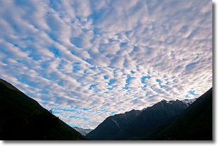
Weather Topic: What are Altocumulus Clouds?
Home - Education - Cloud Types - Altocumulus Clouds
 Next Topic: Altostratus Clouds
Similar to cirrocumulus clouds, altocumulus clouds are
characterized by cloud patches. They are distinguished by larger cloudlets
than cirrocumulus clouds but are still smaller than stratocumulus clouds.
Altocumulus clouds most commonly form in middle altitudes (between 2 and 5 km)
and may resemble, at times, the shape of a flying saucer.
These uncommon formations, called altocumulus lenticularis, are created by uplift
in the atmosphere and are most often seen in close proximity to mountains.
Next Topic: Altostratus Clouds
Current conditions powered by WeatherAPI.com


