Weather Alert in Arkansas
Flood Warning issued February 16 at 9:26AM CST until February 22 at 6:00AM CST by NWS Little Rock AR
AREAS AFFECTED: Bradley, AR; Calhoun, AR; Union, AR
DESCRIPTION: ...The National Weather Service in Little Rock AR has issued a Flood Warning for the following river in Arkansas... Ouachita River At Thatcher L&D affecting Calhoun, Bradley and Union Counties. For the Ouachita River...including Jones Mill DCP, Arkadelphia, Camden, Thatcher L&D...Minor flooding is forecast. * WHAT...Minor flooding is forecast. * WHERE...Ouachita River at Thatcher L&D. * WHEN...From Wednesday evening to Sunday morning. * IMPACTS...At 79.0 feet, Property in low lying areas needs to be removed. Access roads to oil and gas rigs may be flooded. Levee gates should be closed before the river reaches 80 feet. There is minor flooding at this level. At 80.0 feet, Minor flooding occurs at this level. Levee gates should be closed to prevent the river from backing into Calion Lake. Access to oil and gas rigs and to timber is flooded. There is wide coverage of flooding in the river bottoms. * ADDITIONAL DETAILS... - At 8:30 AM CST Monday the stage was 77.8 feet. - Forecast...The river is expected to rise above flood stage late Wednesday evening to a crest of 79.5 feet Thursday evening. It will then fall below flood stage early Saturday morning. - Flood stage is 79.0 feet. - http://www.weather.gov/safety/flood
INSTRUCTION: Turn around, don't drown when encountering flooded roads. Most flood deaths occur in vehicles. Motorists should not attempt to drive around barricades or drive cars through flooded areas. Flooding is occurring or is imminent. Most flood related deaths occur in automobiles. Do not attempt to cross water covered bridges, dips, or low water crossings. Never try to cross a flowing stream, even a small one, on foot. To escape rising water find another route over higher ground. River forecasts are based on current conditions and rainfall forecasted to occur over the next 24 hours. During periods of flooding...Evening forecasts are reissued with updated rainfall forecasts. Observed and forecasted stage data plots are available on our Advanced Hydrologic Prediction Service web page at... www.weather.gov/lzk Under the Current Conditions section...Select River and Lakes AHPS. The next statement will be issued Tuesday morning at 930 AM CST.
Want more detail? Get the Complete 7 Day and Night Detailed Forecast!
Current U.S. National Radar--Current
The Current National Weather Radar is shown below with a UTC Time (subtract 5 hours from UTC to get Eastern Time).

National Weather Forecast--Current
The Current National Weather Forecast and National Weather Map are shown below.

National Weather Forecast for Tomorrow
Tomorrow National Weather Forecast and Tomorrow National Weather Map are show below.

North America Water Vapor (Moisture)
This map shows recent moisture content over North America. Bright and colored areas show high moisture (ie, clouds); brown indicates very little moisture present; black indicates no moisture.

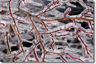
Weather Topic: What is Freezing Rain?
Home - Education - Precipitation - Freezing Rain
 Next Topic: Graupel
Freezing rain is a condition where precipitation which has fallen in the form of
water droplets reaches temperatures which are below freezing and freezes upon
coming into contact
with surface objects. The result of this precipitation is a glaze of ice which
can be damaging to plants and man-made structures. A severe onset of freezing
rain which results in a very thick glaze of ice is known as an ice storm.
Next Topic: Graupel
Weather Topic: What is Hail?
Home - Education - Precipitation - Hail
 Next Topic: Hole Punch Clouds
Hail is a form of precipitation which is recognized by large solid balls or
clumps of ice. Hail is created by thunderstorm clouds with strong updrafts of wind.
As the hailstones remain in the updraft, ice is deposited onto them until their
weight becomes heavy enough for them to fall to the earth's surface.
Hail storms can cause significant damage to crops, aircrafts, and man-made structures,
despite the fact that the duration is usually less than ten minutes.
Next Topic: Hole Punch Clouds
Current conditions powered by WeatherAPI.com


