Weather Alert in New Jersey
Rip Current Statement issued August 23 at 10:35AM EDT until August 24 at 8:00PM EDT by NWS Mount Holly NJ
AREAS AFFECTED: Coastal Atlantic; Coastal Ocean
DESCRIPTION: * WHAT...For the Coastal Flood Warning, up to one half foot of inundation above ground level in low-lying areas near shorelines and tidal waterways. For the High Rip Current Risk, dangerous rip currents. * WHERE...Coastal Atlantic and Coastal Ocean. * WHEN...For the Coastal Flood Warning, until 2 AM EDT Sunday. For the High Rip Current Risk, through Sunday evening. * IMPACTS...At this level, flooding begins on the most vulnerable roads in coastal and bayside communities, and along inland tidal waterways. Some partial or full road closures are possible. Rip currents can sweep even the best swimmers away from shore into deeper water. * ADDITIONAL DETAILS...Localized moderate tidal flooding remains possible with the Saturday night high tide, particularly along the backbays that remain slow to drain.
INSTRUCTION: A Coastal Flood Warning means that moderate or major tidal flooding is occurring or imminent. Be prepared for rising water levels and take appropriate action to protect life and property. Follow the recommendations of local emergency management officials. Do not drive your vehicle through flood waters. The water may be deeper than you think it is. You will be putting yourself in danger and your vehicle may be damaged, leading to costly repairs. Visit the National Water Prediction Service at https://water.noaa.gov/phi for additional water level and flood impact information for your local tide gauge. Always obey posted Beach Flags. If you enter the surf zone, always have a floatation device with you and swim near a lifeguard if possible. If caught in a rip current, relax and float and do not swim against the current. If able, swim parallel to the shoreline. If unable to escape, face the shore and call or wave for help.
Want more detail? Get the Complete 7 Day and Night Detailed Forecast!
Current U.S. National Radar--Current
The Current National Weather Radar is shown below with a UTC Time (subtract 5 hours from UTC to get Eastern Time).

National Weather Forecast--Current
The Current National Weather Forecast and National Weather Map are shown below.

National Weather Forecast for Tomorrow
Tomorrow National Weather Forecast and Tomorrow National Weather Map are show below.

North America Water Vapor (Moisture)
This map shows recent moisture content over North America. Bright and colored areas show high moisture (ie, clouds); brown indicates very little moisture present; black indicates no moisture.

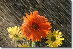
Weather Topic: What is Precipitation?
Home - Education - Precipitation - Precipitation
 Next Topic: Rain
Precipitation can refer to many different forms of water that
may fall from clouds. Precipitation occurs after a cloud has become saturated to
the point where its water particles are more dense than the air below the cloud.
In most cases, precipitation will reach the ground, but it is not uncommon for
precipitation to evaporate before it reaches the earth's surface.
When precipitation evaporates before it contacts the ground it is called Virga.
Graupel, hail, sleet, rain, drizzle, and snow are forms of precipitation, but fog
and mist are not considered precipitation because the water vapor which
constitutes them isn't dense enough to fall to the ground.
Next Topic: Rain
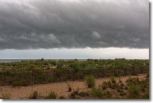
Weather Topic: What are Shelf Clouds?
Home - Education - Cloud Types - Shelf Clouds
 Next Topic: Sleet
A shelf cloud is similar to a wall cloud, but forms at the front
of a storm cloud, instead of at the rear, where wall clouds form.
A shelf cloud is caused by a series of events set into motion by the advancing
storm; first, cool air settles along the ground where precipitation has just fallen.
As the cool air is brought in, the warmer air is displaced, and rises above it,
because it is less dense. When the warmer air reaches the bottom of the storm cloud,
it begins to cool again, and the resulting condensation is a visible shelf cloud.
Next Topic: Sleet
Current conditions powered by WeatherAPI.com


