Weather Alert in Minnesota
Winter Weather Advisory issued April 2 at 4:05PM CDT until April 3 at 4:00PM CDT by NWS Twin Cities/Chanhassen MN
AREAS AFFECTED: Lac Qui Parle; Swift; Chippewa; Kandiyohi; Yellow Medicine; Renville; Redwood
DESCRIPTION: ...FIRST ROUND OF WINTRY PRECIPITATION IS WRAPPING UP, ANOTHER ROUND OF FREEZING RAIN AND SNOW IS EXPECTED FOR TOMORROW... .A Winter Weather Advisory for western and central Minnesota goes into effect Friday for our next wintry system. Portions of western Minnesota will see a round of freezing rain and sleet early Friday with accumulations of up to two tenths of an inch. Further north, precipitation will start out as a wintry mix before transitioning to all snow late Friday. Snowfall totals of 3 to 5 inches are expected with around a tenth of an inch of ice accumulation. East central Minnesota will see 2 to 4 inches of snow along with ice accumulations up to two tenths of an inch. * WHAT...Mixed precipitation expected. Total snow accumulations up to one inch, sleet accumulations between one tenth and two tenths of an inch, and ice accumulations up to two tenths of an inch. * WHERE...Kandiyohi, Renville, Redwood, Chippewa, Lac Qui Parle, Swift, and Yellow Medicine Counties. * WHEN...From 7 AM to 4 PM CDT Friday. * IMPACTS...Plan on slippery road conditions. The hazardous conditions will impact the Friday morning and evening commutes.
INSTRUCTION: Slow down and use caution while traveling. Call 5 1 1 or visit 511mn.org for road conditions.
Want more detail? Get the Complete 7 Day and Night Detailed Forecast!
Current U.S. National Radar--Current
The Current National Weather Radar is shown below with a UTC Time (subtract 5 hours from UTC to get Eastern Time).

National Weather Forecast--Current
The Current National Weather Forecast and National Weather Map are shown below.

National Weather Forecast for Tomorrow
Tomorrow National Weather Forecast and Tomorrow National Weather Map are show below.

North America Water Vapor (Moisture)
This map shows recent moisture content over North America. Bright and colored areas show high moisture (ie, clouds); brown indicates very little moisture present; black indicates no moisture.

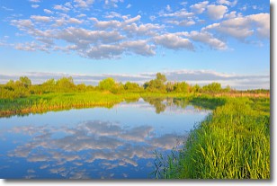
Weather Topic: What are Stratocumulus Clouds?
Home - Education - Cloud Types - Stratocumulus Clouds
 Next Topic: Stratus Clouds
Stratocumulus clouds are similar to altocumulus clouds in their
fluffy appearance, but have a slightly darker shade due to their additional mass.
A good way to distinguish the two cloud types is to hold your hand out and measure
the size of an individual cloud; if it is the size of your thumb it is generally
an altocumulus cloud, if it is the size of your hand it is generally a
stratocumulus cloud.
It is uncommon for stratocumulus clouds to produce precipitation, but if they do
it is usually a light rain or snow.
Next Topic: Stratus Clouds
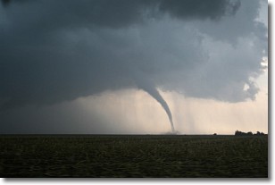
Weather Topic: What are Wall Clouds?
Home - Education - Cloud Types - Wall Clouds
 Next Topic: Altocumulus Clouds
A wall cloud forms underneath the base of a cumulonimbus cloud,
and can be a hotbed for deadly tornadoes.
Wall clouds are formed by air flowing into the cumulonimbus clouds, which can
result in the wall cloud descending from the base of the cumulonimbus cloud, or
rising fractus clouds which join to the base of the storm cloud as the wall cloud
takes shape.
Wall clouds can be very large, and in the Northern Hemisphere they generally
form at the southern edge of cumulonimbus clouds.
Next Topic: Altocumulus Clouds
Current conditions powered by WeatherAPI.com


